
DC Weather: A Weekend Storm on the Horizon
The DC area is bracing for a potentially impactful storm system this weekend. While weather models are still debating the specifics, the most likely scenario involves a transition from rain on Sunday morning to a wintry mix, and eventually, wet snow by Sunday night. FOX 5’s Mike Thomas provides the latest details on what to expect.
A Break from the “Snowcrete”
Compared to the recent weeks dominated by the persistent “snowcrete,” this past week has been relatively mild in the DC region. Temperatures have consistently remained above freezing, gradually easing the grip of the lingering snow and ice. Saturday is shaping up to be the best day of the week, with partial sunshine and temperatures reaching the mid-50s.
The Shift in the Pattern
However, the pattern will begin to shift on Saturday night. A strong dip in the jet stream will cause temperatures to fall into the 30s overnight, setting the stage for a developing storm system. This system has the potential to bring a variety of precipitation types to the DC area, including the possibility of accumulating snowfall.
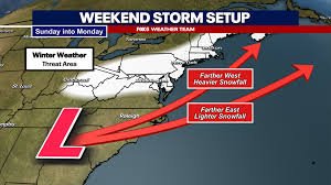
The Snow Debate: Model Discrepancies
The big question, of course, is: how much snow can we expect? This remains a challenging question, even with just a few days to go. The key lies in the storm’s track and intensity – two factors that weather models have been struggling to predict consistently.
The European Model
Currently, our weather department leans slightly towards the European model’s solution. This scenario suggests the system will begin as rain on Sunday morning, as temperatures are well above freezing. As the storm moves eastward into the Atlantic, colder air will filter in, potentially changing the rain to a mix and then to heavy, wet snow on Sunday night. The snowfall would likely be localized within a relatively narrow band, making precise forecasting difficult until closer to Saturday evening. This solution could bring 1-3 inches of snow, with a potential for up to 6 inches in some areas.
The American Model
The American model, on the other hand, paints a more dramatic picture. It suggests a stronger, more impactful storm system that stays closer to the coastline. This would result in a quicker drop in temperatures and a widespread, heavy snowfall, potentially exceeding 10 inches. However, most forecasters agree that this scenario is less likely.
Model Inconsistency and the Challenges of Forecasting
The current issue is model inconsistency. Weather models have been particularly unreliable with this storm system. Even the European model has been fluctuating between different scenarios. This is due to the complex interplay of multiple atmospheric energy sources influencing the storm’s development, making accurate forecasting more challenging.
What to Prepare For
While it’s unlikely to be a repeat of the late January storm, residents should be prepared for potential impacts. Temperatures will not be as frigid, and any snowfall will likely be wet and subject to some ground melt. It’s important to remember that weather apps often provide the high temperature for the day. Dynamic cooling can occur as colder air moves in, leading to falling temperatures throughout the day, especially Sunday afternoon and evening.
While a major city shutdown is not anticipated, there is a risk of school closures and delays on Monday morning. FOX 5 will continue to monitor the situation and provide updates as they become available.
Stay Tuned for Updates
We are currently leaning towards a lower-impact accumulating winter snowfall event, rather than a major snowstorm. FOX 5 will continue to monitor the threat and keep you informed. For more information on weather safety and preparedness, visit the National Weather Service website.
All the news you need to know, every day.
This material may not be published, broadcast, rewritten, or redistributed. ©2026 FOX Television Stations


