New Jersey Braces for Back-to-Back Snow Storms
New Jersey residents are preparing for a wintry weekend as two successive winter storms are forecast to bring snow to the state. The first storm is expected to hit on Saturday, with 2 to 4 inches of snow predicted for northern counties. A second, lighter snowfall is anticipated on Sunday, particularly in the southern half of the state, with accumulations of 1 to 2 inches.
Saturday’s Storm: Heavy Snow North of I-78
According to the National Weather Service (NWS), the heaviest snowfall from Saturday’s storm will occur north of Interstate 78. A Winter Weather Advisory is currently in effect until 4 p.m. Saturday for Morris, Sussex, Warren, and western Passaic counties. Travel conditions could become hazardous, with snowfall rates potentially exceeding 1 inch per hour between 9 a.m. and 1 p.m. in these areas.
Counties between I-78 and I-95 are expected to receive around 1 inch or less of snow. Further south, near and below I-95, warming temperatures will likely cause a transition from snow to rain by mid-morning, minimizing accumulation.
Sunday’s Storm: Coastal Impact
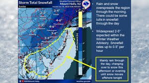
Sunday will bring another round of light snow, primarily affecting areas along and south of I-95 as a coastal storm brushes the Jersey Shore. The NWS anticipates the snow to begin early Sunday morning and continue through the early evening. Winter weather advisories may be issued for coastal areas as the forecast becomes more certain.
Up to 2 inches of snow is possible south and east of I-95, with some locations in Atlantic, Cape May, southwestern Burlington, and southern Ocean Counties potentially exceeding 2 inches. There’s approximately a 30% chance of snowfall exceeding 2 inches in these areas. Uncertainty remains regarding snow accumulation in coastal regions due to the possibility of mixing with rain.
Frigid Temperatures Following the Storms
Beyond the snow, a prolonged period of below-normal temperatures is expected from Sunday night through Wednesday. The coldest conditions are forecast for Monday night through Tuesday, with wind chills dropping into the single digits statewide. Tuesday will be particularly brutal, with highs remaining in the 20s and wind chills in the single digits and low teens.
A break from the cold is anticipated on Wednesday, with temperatures moderating towards more seasonable levels, potentially rising above normal by Thursday. However, a cold front late in the week could bring temperatures back down to near or slightly below normal heading into the weekend.
Looking Ahead: Potential for More Winter Weather
AccuWeather’s long-range forecast suggests the possibility of additional snow and ice. Senior Long-Range Meteorologist Joe Lundberg notes that a shift in the jet stream pattern could allow storms to spread snow and ice across the Central and Eastern states. You can find more detailed long-range forecasts on AccuWeather’s website.
Stay updated with the latest forecasts from the National Weather Service and local news sources to ensure your safety during these winter storms.


