
Winter Storm Iona: A Deep Dive into Snowfall Totals and Impacts
A significant winter storm, dubbed Winter Storm Iona by The Weather Channel, is poised to unleash blizzard conditions, record snowfall, and dangerously high winds across the upper Midwest and Great Lakes this weekend. Following this, a blast of frigid air will sweep across much of the East and South. This dramatic shift in weather comes on the heels of a recent period of record warmth in the central and eastern U.S., which is now giving way to a record March heat wave in the Southwest.
Current Alerts and Conditions
Before Iona arrives, a wintry system is already impacting the Great Lakes and Northeast with strong winds and some snow, having previously swept through the Northwest, northern Rockies, and Plains. However, the weekend storm is forecast to be far more widespread and intense.
- Blizzard Warnings: Issued for portions of South Dakota and Minnesota, where wind gusts up to 50 mph combined with moderate to heavy snow will create near-impossible travel conditions on Sunday.
- Winter Storm Watches & Warnings: In effect from the Northern Rockies to the Upper Midwest.
- High Wind Watches & Warnings: Covering parts of the Rockies and Plains, with potential gusts exceeding 70 mph, posing a threat of tree damage and power outages.
Timing and Forecast
By late Saturday, a broad area of snow will blanket the Northern Plains, Northern Rockies, and Great Lakes. On Sunday, a strong low-pressure system will move eastward from the Plains to the Great Lakes, bringing heavy snow and gusty winds to the Northern Plains and Upper Midwest, including the Upper Peninsula of Michigan. Some mixed precipitation, including sleet and ice, is likely from Iowa through southern Wisconsin and central Michigan.
Ahead of the cold front, severe thunderstorms are expected from eastern Texas to the Ohio Valley, including areas recently impacted by severe weather. Rain could extend as far north as Milwaukee and Lansing, Michigan.
Sunday & Monday’s Outlook
Sunday night and Monday, the strong low will push the cold front rapidly into the East. Precipitation may briefly change from rain to snow in the Ohio Valley and Appalachians. Along much of the East Coast, rain is expected, with the potential for strong to severe thunderstorms and damaging winds from the Northeast to the Carolinas.
Strong winds will persist in the Midwest and East into Monday, potentially causing power outages, especially near the Great Lakes and along the East Coast.
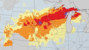
Snowfall Totals: Where Will the Snow Be Deepest?
Parts of the upper Midwest could experience a record-setting snowstorm. Areas from southern Minnesota into central and northern Wisconsin, far northern Lower Michigan, and Upper Michigan are likely to see over a foot of snow. Some locations may even receive 18 to 24 inches, or locally more. This includes cities like Green Bay, Marquette, and Mackinac Island.
NOAA records suggest that some locations in northeast Wisconsin, eastern Upper Michigan, and extreme northern Lower Michigan could flirt with or break 2-day snowstorm records. Snowfall rates of 1 to 3 inches per hour are possible Sunday and Monday, accompanied by strong winds, creating extremely dangerous travel conditions. Travelers in the western Great Lakes and upper Midwest are advised to consider delaying or canceling plans.
A band of freezing rain and sleet is also possible from parts of extreme northern Iowa and southern Minnesota into southern Wisconsin and Lower Michigan Sunday, potentially leading to slippery roads. These conditions, combined with strong winds and heavy snow, could cause widespread tree damage and power outages.
Significant snowfall is not expected in the Northeast, with rain being the dominant precipitation type.
A Deep Freeze Follows
This weekend’s blizzard will usher in a fresh supply of cold air from Canada, with lasting effects into St. Patrick’s week. By Sunday, the cold will reach the Plains, and by Monday, it will extend to the northern Gulf Coast. By Tuesday, the cold air will have swept through the East, including Florida.
Highs will struggle to reach the teens, 20s, and 30s in much of the Midwest on Monday. St. Patrick’s Day will see temperatures in the 20s and 30s across most of the Northeast and Midwest, while the Southeast shivers in the 40s and 50s. Subzero lows are possible in parts of North Dakota, Minnesota, Wisconsin, and Michigan’s Upper Peninsula. Even parts of the Deep South, including northern Florida, could dip below freezing Tuesday and Wednesday morning.
Looking Ahead
While the immediate forecast calls for a prolonged cold snap, warmer air is expected to return to the Plains by mid-week and potentially spread eastward later in the week. However, some longer-range models suggest a return of chillier air to the Midwest and Northeast around March 21-22.
Source: The Weather Channel


