
Weather in Miami: Prepare for a Powerful Cold Front This Weekend
A significant cold front is poised to impact the Miami area this weekend, bringing with it a combination of rain, gusty winds, and dangerously high surf. Local weather experts are closely monitoring the situation, and have designated Sunday as a high-impact weather day due to the potential for disruptive conditions.
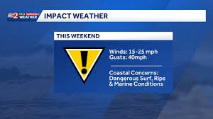
What to Expect: Wind, Rain, and Hazardous Surf
Winds are forecast to range between 15 and 25 mph, with gusts potentially reaching up to 40 mph. The National Weather Service (NWS) has issued a Gale Warning for all coastal counties through Sunday, highlighting the severity of the expected conditions. These strong winds will create hazardous conditions for boaters and beachgoers alike.
Beyond the wind, residents can anticipate a high risk of rip currents. A High Surf Advisory is currently in effect and extends through Monday, meaning dangerous waves and strong currents will persist along the coastline. Persistent onshore winds will also maintain a chance of showers throughout the week, though widespread, all-day rain is not anticipated.
Coastal Concerns & Safety Precautions
The approaching weather system poses significant risks for those near the coast. Dangerous surf and seas are expected to linger into early next week. It’s crucial to heed all warnings from local authorities and avoid entering the water during this period. Remember, rip currents are powerful and can quickly pull even strong swimmers out to sea.
Here’s what you should do:
- Stay informed: Monitor local news and weather updates regularly.
- Avoid the beach: Refrain from swimming, surfing, or engaging in any water activities.
- Secure loose objects: Bring in outdoor furniture, decorations, and anything else that could be blown away by the wind.
- Be prepared for power outages: Have a flashlight, batteries, and a backup power source readily available.
Temperature Outlook
Following the passage of the cold front, cooler temperatures are expected on Sunday and Monday. However, a gradual warming trend is forecast for the remainder of the week. This shift in temperature will be a welcome change after the initial impact of the front.
What is Impact Weather?
“Impact Weather” signifies conditions that could disrupt travel plans and daily routines. It’s a designation used by weather forecasters to alert the public to potentially hazardous situations.
Stay updated with the latest news and alerts by downloading the WESH 2 News app for your phone or tablet. You can also stream news and entertainment with the Very Local app.


