
Tornadoes: Tracking the Severe Weather Threat Across the US
A volatile weather pattern is unleashing a series of severe thunderstorms and confirmed tornadoes across the Plains and Midwest, with the threat extending into the eastern Great Lakes. After a particularly active period, damaging winds and the potential for further tornado development remain a significant concern as we move into the weekend.
Recent Tornado Activity
Multiple tornadoes have already been confirmed, leaving a trail of destruction in their wake. Near Elgin, Minnesota, a tornado overturned a semi-truck and caused damage to two farmsteads. Further south, in the Rochester area of Minnesota, another tornado inflicted damage on homes in Marion. Early Friday morning, parts of Minnesota experienced severe thunderstorms with quarter-sized hail reported in Kasota and New Ulm. Tama, Iowa, saw even larger hail, reaching tennis ball size.
Current and Future Threats
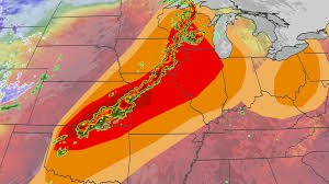
The threat of severe weather isn’t limited to Friday. Strong to severe thunderstorms are possible from the Southern Great Lakes to the Ozarks overnight, bringing the risk of damaging wind gusts, large hail, isolated tornadoes, and flash flooding. This is expected to evolve into squall lines of severe thunderstorms with embedded tornadoes, capable of downing trees, damaging property, and causing power outages.
While Saturday may see some isolated severe thunderstorms in the eastern Great Lakes and Ohio Valley, the activity isn’t expected to be as widespread as Friday. Fortunately, a three-day respite from severe weather is anticipated as a cold front sweeps across the East Coast.
Flooding Concerns
Beyond the immediate tornado threat, significant flooding is occurring across the western Great Lakes due to a combination of heavy rainfall and melting snow. This risk extends as far south as Missouri. Rivers in Michigan and Wisconsin are already at or forecast to reach major flood stage. An additional 1-inch-plus of rainfall is expected across a broad area from eastern Kansas and northern Oklahoma to the Southern Great Lakes through Saturday, potentially leading to dangerous flash flooding, especially in urban areas and saturated ground.
The Science Behind the Storms
The current weather pattern is driven by a high-pressure system over the eastern U.S., forcing Gulf moisture northward across the Plains. This, combined with southward plunges of the jet stream, creates an environment conducive to severe weather. The persistent high-pressure system and recurring troughs mean many areas could experience repeated days of severe weather.
Recent Severe Weather Reports (Monday – Wednesday)
- Monday: 19 tornado reports, including confirmed tornadoes in Minnesota, Wisconsin, and Kansas. An EF2 tornado was confirmed in Franklin County, Kansas.
- Tuesday: A strong EF3 tornado (140 mph winds) destroyed a home near Union City, Wisconsin – the strongest April tornado in the state in 15 years. An EF2 tornado damaged a commercial facility and a church near Milwaukee.
- Wednesday: Wind-driven hail caused damage in parts of Kansas, Nebraska, and Ohio. Flash flooding impacted Milwaukee, Wisconsin, even leaking through the roof of American Family Field during a baseball game.
As of Thursday night, over 750 reports of severe weather, including nearly 50 tornado reports, have been recorded. The National Weather Service is conducting further surveys to determine the exact number of tornadoes.
Stay informed: The Weather Channel provides up-to-date forecasts and safety information.
Source: Rob Shackelford, a meteorologist and climate scientist at weather.com.


