
Columbus Weather Update: Prepare for High Winds and a Rapid Temperature Plunge
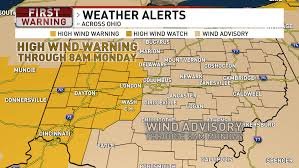
Current Conditions: Currently 50°F. Tuesday’s high: 27°F. Wednesday’s high: 41°F. Central and Western Ohio are under a High Wind Warning, with a Wind Advisory in effect for the rest of the region, extending through tonight and into early Monday morning.
Powerful Storm System Approaching
A powerful storm system is rapidly approaching the Ohio Valley, bringing with it sustained strong winds. Gusts are expected to reach 45-50 mph, particularly in Western Ohio, throughout the evening. While winds may briefly subside after sunset, a strong cold front will cause them to intensify again late tonight.
ALERT DAY: Fast-Moving Storm & Potential for Severe Winds
We’ve issued an ALERT DAY as a fast-moving line of showers and thunderstorms is forecast to sweep across the region from west to east between 2 AM and 6 AM Monday. Although the storms will be quick-moving, the extremely windy conditions aloft pose a risk of isolated wind gusts exceeding 50 mph reaching the surface.
Dramatic Temperature Drop & Potential Snow
Once the storm front passes, the severe weather threat will diminish, but a dramatic shift in temperature is expected. Temperatures will plummet nearly 30 degrees in just a few hours before sunrise on Monday. Rain may briefly mix with, or change to, snow before daybreak, though any accumulation will likely be minimal and confined to grassy or elevated surfaces.
Looking Ahead: Coldest Air of the Season
- Monday: Scattered snow showers and strong winds will persist throughout the day.
- Monday Night/Tuesday Morning: The coldest air arrives, with temperatures potentially dropping into the teens across much of the area.
- Tuesday: Highs will struggle to reach the upper 20s to lower 30s.
Stay tuned to local forecasts for the latest updates and be prepared for hazardous travel conditions. You can find more information from the National Weather Service.
Source: WSYX


