
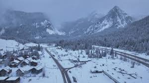
Blizzard Warning Issued for Cascade Mountains
SEATTLE – The Pacific Northwest is bracing for a significant winter storm, with a Blizzard Warning in effect for the Cascade Mountains beginning Wednesday evening. Forecasters predict up to 1 to 3 feet of snow, coupled with powerful, gusty winds, creating dangerous conditions. Residents in the lowlands should also prepare for heavy rainfall and strong winds, potentially leading to localized flooding and power outages.
What is a Blizzard Warning?
The National Weather Service (NWS) issues a Blizzard Warning when conditions meet specific criteria: substantial snowfall, sustained winds exceeding 35 mph, and visibility reduced to less than a quarter of a mile – all lasting for at least three hours. While snowfall is common in the Cascades, the combination of sustained high winds during a snow event is less frequent.
Interestingly, NWS Seattle has issued only seven Blizzard Warnings to date, with four occurring in the last two years, highlighting the increasing intensity of recent winter storms.
Impacts and Forecast Details
The most widespread impacts are expected on Wednesday, with a Wind Advisory covering much of the lowland areas. Here’s a breakdown of what to expect over the next 48 hours:
- Cascade Mountains: Expect 1-3 feet of snow and sustained high winds. Travel may become “impossible at times,” and falling tree branches pose a hazard. Avalanche danger will be high due to the combination of heavy, wet snow falling on existing, lighter snowpack.
- Lowlands: Heavy rain and gusty winds up to 50 mph are anticipated, particularly overnight Wednesday and into Thursday.
- Snow Levels: Snow levels are expected to rise to 4,000 to 5,000 feet Wednesday evening, potentially impacting Snoqualmie Pass, White Pass, and even Stevens Pass with rain.
A stronger, warmer system is moving into western Washington after a brief respite Wednesday morning. This system will bring the heaviest precipitation and strongest winds.
Looking Ahead
The current weather system is forecast to move through by Thursday morning, offering a brief period of calmer conditions. However, another system is already on its way, promising additional precipitation. A ridge of high pressure is expected to bring drier conditions to the region by Saturday.
Sunday will see the arrival of a warm front, bringing more rain and pushing snow levels up to 5,000 feet. This trend will continue into Monday and Tuesday, with snow levels climbing to 6,000 to 8,000 feet.
Through Friday, the region could experience significant total precipitation. Forecast details are subject to change, so stay tuned for updates.
Stay Informed
KING 5 has activated its First Alert Weather Team to provide the latest information and keep you and your family safe during this potentially dangerous weather event. You can stream KING 5 on your phone by downloading the KING 5 app.
For more information and updates, visit the National Weather Service website.


