
Boston Weather: Two Storms on the Horizon
Winter isn’t quite ready to release its grip on New England. Boston and the surrounding areas are bracing for not one, but two potential storms. The first, arriving Friday afternoon, promises a mix of wintry precipitation, while a coastal storm looms over the weekend, potentially impacting Southeastern New England Sunday night into Monday.
Friday’s Wintry Mix: What to Expect
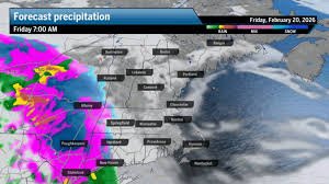
While uncertainties remain, the forecast for Friday’s storm is becoming clearer. Expect a transition from cold rain to a wintry mix of sleet and snow across most of New England. Areas north of the Massachusetts Turnpike (Mass Pike) are likely to see accumulating, plowable snow. Southern areas, including Boston, will likely experience a mix or cold rain for much of the day, transitioning to snow overnight.
- Boston: 1-3 inches of snow by noon Saturday.
- Northern New England: 3-6 inches, with localized totals up to 6-8 inches in parts of Vermont, New Hampshire, and Western Maine.
- Southern New England: Minor ice accumulation away from the coast.
Winds are not expected to be a significant factor with this system.
Storm Breakdown: Timing and Impacts
The system will move into New England from the southwest, reaching Boston by early afternoon. Here’s a timeline:
- 6-8 a.m.: Southwestern Connecticut
- 8-11 a.m.: Western Massachusetts, Rhode Island, Southern Vermont, Central & Eastern Connecticut
- 11 a.m. – 2 p.m.: Eastern Massachusetts (including Boston), Cape Cod, Islands, most of New Hampshire, and parts of Vermont
- 2-5 p.m.: Northern New Hampshire and most of Maine
The evening commute on Friday could be challenging due to steady precipitation. A secondary low forming over the Gulf of Maine may intensify snowfall rates for those seeing snow, while steady rain is possible south of the rain-snow line.
Weekend Outlook & The Coastal Storm
The weekend will be relatively quiet, with lingering snow showers tapering off Saturday morning. Be cautious of icy spots, especially west of I-495, on Saturday morning. Skies will clear by Saturday afternoon, with highs in the low 30s.
Sunday will be mostly quiet with a few snow showers, but no significant accumulation is expected.
A Coastal Storm on the Horizon
A coastal storm forming off the Carolina coast early Sunday is being closely monitored. The interaction between this storm and a low-pressure system moving into New England from the west will determine its impact. While a full-blown nor’easter is unlikely, a ‘brush’ of snow is more probable for Providence to Boston and southeastern areas.
Models are currently showing varying scenarios. The GFS model suggests up to a foot of snow for Boston and 20 inches on Cape Cod, but this is considered a worst-case scenario. More likely, the Euro-AI or ICON models predict 2-4 inches for Boston to Providence and 4-8 inches for the Cape.
Stay tuned for updates as the forecast evolves!
For daily weather updates delivered straight to your inbox, sign up for our daily Globe Weather Forecast.
Source: Boston.com Weather


