
Winter Storm Warning: Washington State Braces for Late-Season Blast
After a seemingly early exit, winter is making a dramatic return to Washington State. Following months of mild weather, residents are now facing a potent winter storm bringing heavy snow to the mountains, periods of cool rain in the lowlands, and dangerously gusty winds. Current temperatures are 42°F, with forecasts of 45°F for Thursday and 41°F for Friday.
Atmospheric River and Mountain Snowfall
An extended plume of moisture, known as an atmospheric river, is expected to impact the Northwest from tonight through Thursday. While not a “Pineapple Express” – a system drawing warmer air from Hawaii – this storm will deliver steady precipitation. Crucially, snow levels are predicted to remain near pass level, unlike the warmer storms experienced in December. The Cascades are already blanketed in fresh snow, with Stevens Pass reporting nearly 3 feet in the last 48 hours.
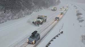
Winter Storm Warning and Blizzard Conditions
A Winter Storm Warning is currently in effect for the Cascades, anticipating an additional 1 to 2 feet of snow within the next 24 hours. The combination of heavy snowfall and strong winds has prompted a rare Blizzard Warning for the mountains, beginning Wednesday evening. Winds could exceed 60 mph near mountain peaks, creating hazardous travel conditions. Travel across the Cascades is expected to be particularly dangerous Wednesday night.
Related: NBC News – Winter Storm Warning and Blizzard Warning for Pacific Northwest
Lowland Impacts: Rain and Gusty Winds
In the lowlands, expect periods of cool March rain on Wednesday, impacting both morning and evening commutes. High temperatures will hover around 50°F, close to the seasonal average. However, the real concern lies with the wind. Southerly winds of 30 to 50 mph, with gusts up to 55 mph, are forecast across the region, including along the coast and through Puget Sound. The strongest winds, between Kitsap and King counties, are expected between 7 p.m. and 11 p.m. Wednesday. A Wind Advisory is in effect, and these gusty conditions could lead to tree damage and power outages.
As the storm moves eastward, winds will shift to the west in the Strait of Juan de Fuca and the San Juan Islands, with gusts potentially reaching 40 to 55 mph in areas like Oak Harbor, Port Angeles, and Anacortes.
Looking Ahead: Continued Stormy Weather and a Potential Cold Snap
Thursday will see easing winds, but rain in the lowlands and snow in the mountains will persist. Snow levels are expected to remain near 2,000 feet through Thursday and Friday, adding to late-season snowfall at the passes and ski areas. Another push of colder air is anticipated Friday night into Saturday, potentially lowering snow levels to around 500 feet by Saturday morning, with a chance of brief, light lowland snow accumulations. Highs on Saturday will struggle to reach the lower 40s.
Fortunately, conditions are expected to improve by Sunday and Monday, with drier weather and increasing sunshine just in time for St. Patrick’s Day. Highs could approach 60°F by Monday afternoon. For now, winter is making one final, impactful push.
Image courtesy of the KOMO 4 Forecast Team. (KOMO News)
Source: KOMO News


