
Wind Advisory Issued: Brace for Impact!
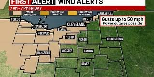
CLEVELAND, Ohio – A significant cold front is moving through the region tomorrow, bringing with it a sharp temperature decrease and, more importantly, strong winds. A Wind Advisory has been issued for several counties, effective from 7 a.m. to 7 p.m. today. Residents are urged to prepare for potentially hazardous conditions.
What to Expect: Strong Winds and Falling Temperatures
Southwesterly winds are expected to gust up to 50 mph, posing a risk of power outages and making travel difficult, especially for high-profile vehicles. The National Weather Service warns that these gusts are strong enough to down tree branches and create hazardous driving conditions. Be sure to secure outdoor objects that could be blown around.
Currently, temperatures are in the mid to upper 50s for most areas. However, a lake breeze is keeping temperatures cooler along the lakeshore, in the low to mid 40s. Expect a “murkier” day with increased cloud cover and lingering fog into the early afternoon.
Rain and Thunderstorm Potential
Scattered showers are possible throughout the day, but a more widespread rain system will arrive tonight. Within this rain, there’s a chance of thunderstorms with heavy downpours and, again, gusty winds. While the risk of severe weather is low, it’s important to stay aware of changing conditions. You can find more information about thunderstorm safety at the National Weather Service website.
Looking Ahead: A Chilly Weekend
Overnight lows will hover in the 40s. The rain will clear out early Friday morning, but temperatures will continue to fall. Expect highs in the low 50s by midday Friday, dropping to the 40s and eventually the 30s by sunset. The strong southwest wind will persist, with gusts up to 50 mph. A few snowflakes may even fly in the colder air Friday afternoon, though no accumulation is anticipated.
- Saturday: Dry but cloudy, with highs in the upper 30s.
- Sunday & Monday: Likely snow showers, with afternoon temperatures in the low 30s.
- Tuesday: Cold, but the snow will have moved out.
- Wednesday: Moderating temperatures, returning to the 40s with another chance of showers.
Stay tuned to local forecasts for the latest updates and be prepared for changing weather conditions. Remember to drive cautiously and secure any loose objects around your property.
Copyright 2026 WOIO. All rights reserved.


