
Weather Forecast: Major Snow Storm Approaching – Stay Safe!
A significant winter storm is poised to impact the region, bringing with it the potential for heavy snowfall, strong winds, and blizzard conditions. Here’s a detailed breakdown of what you can expect:
Today & Tonight: A Calm Before the Storm
This afternoon will remain relatively mild with mostly sunny skies. Enjoy the calm while it lasts! As night falls, skies will clear, and winds will be light. However, temperatures will plummet, with lows dropping into the teens and single digits. Prepare for a significant temperature shift.
Thursday: Snow Showers Arrive & Intensify
Thursday morning will start with some sunshine, but clouds will quickly increase throughout the day. The first snow showers will begin to spread in from the southwest after 3 PM, becoming more intense as we approach the evening. The Ports area will experience a rapid increase in snowfall after 5 PM.
Expect moderate to heavy snow to continue overnight, accompanied by sustained east winds of 15-35 mph, with gusts potentially reaching up to 45 mph. These conditions will create blizzard-like conditions along the North Shore and potentially around the head of the lake. Travel will become extremely hazardous.
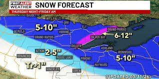
Snowfall Totals (Thursday Night)
- Most of the Region: 5-10 inches
- Southern Areas: Less snow expected
- North Shore: 6-12 inches
Friday: Lingering Snow & Clearing Skies
Friday morning will see lingering snow showers gradually diminishing from west to east. Skies will begin to clear as the day progresses. High temperatures will reach the upper 20s and lower 30s, with breezy northwest winds of 10-20 mph. Conditions will improve, but caution is still advised.
Saturday: A Brief Respite
Saturday is shaping up to be relatively quiet, with partly sunny skies and a slight chance of flurries to the south late in the day. Highs will be in the upper 20s and lower 30s, with southwest winds.
Sunday: Potential for Additional Snow
The chance of snow Saturday night into Sunday has decreased, with current models indicating the heaviest snowfall will remain across Southern Minnesota. However, the situation remains fluid, and conditions could change. Stay tuned for updates as we continue to monitor the system. You can find more information on the National Weather Service website.
Stay Informed: Download the Northern News Now app or our Northern News Now First Alert weather app for the latest updates.
Copyright 2026 Northern News Now. All rights reserved.


