
Snow Storm Weather Forecast: Ontario Braces for Another Round of Winter Weather
Ontario residents are bracing for another impactful winter storm, following closely on the heels of Wednesday’s unpredictable weather. This new system is expected to track a similar path – from southwest to northeast – bringing a mix of precipitation, including rain, freezing rain, and significant snowfall, through Saturday. Understanding the snow storm weather forecast is crucial for safe travel and preparedness.
A Repeat Performance, But With a Twist
Like the mid-week system, this storm will feature a shifting precipitation pattern as it moves across the province. While some areas will experience a straightforward transition from rain to snow, others will encounter a more complex sequence of rain, freezing rain, and then snow. This variability makes it essential to stay updated with the latest weather forecast.
The transition zone is once again expected to settle near the Greater Toronto Area (GTA), creating challenging conditions throughout the day. Drivers should exercise extreme caution and consider postponing non-essential travel.
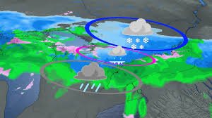
Snowfall Totals: Where Will the Heaviest Snow Fall?
Eastern and central Ontario are forecast to receive the brunt of the snowfall, with accumulations potentially reaching 15 to 20 cm. Cities like Ottawa are expected to see substantial snowfall totals as colder air becomes more firmly established. This significant snowfall will likely impact travel and daily routines.
In contrast, Toronto is expected to remain mild enough for primarily rain, with a simpler rain-to-snow transition. While snowfall amounts will be lower in the city, even a small accumulation can create slippery conditions. Concerns about significant ice pellet accumulation are also lower compared to Wednesday’s storm.
Toronto’s Snowfall So Far This Season
Wednesday’s storm added 6 cm of snow at Toronto Pearson International Airport, bringing the city’s seasonal snowfall total to a remarkable 173 cm. This figure significantly exceeds the average of 115 cm and marks the snowiest winter since 2007-08. You can find more information about winter weather impacts on infrastructure at Transport Canada.
Staying Safe and Informed
With another system on the horizon, winter is far from over, especially for communities east of the GTA. Plows will be working diligently to keep roads clear, but residents are urged to closely monitor forecasts and be prepared for changing conditions. Even minor temperature fluctuations can dramatically alter the type and intensity of precipitation.
Key Takeaways:
- Eastern & Central Ontario: 15-20 cm of snow expected.
- GTA: Primarily rain, with a possible rain-to-snow transition.
- Travel: Exercise extreme caution and consider postponing non-essential trips.
- Stay Informed: Monitor the latest snow storm weather forecast updates.
Stay with The Weather Network for the latest updates across Ontario. We are Canada’s #1 most trusted weather brand and news source* *2026 BrandSpark® Canadian Trust Study & 2026 Pollara Trust in Media Study


