
Snow in Ontario: A Break from the Deep Freeze, But Prepare for More
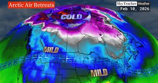
After weeks of bone-chilling cold, Ontario residents may finally be seeing a light at the end of the winter tunnel – at least when it comes to extremely low temperatures. Global News chief meteorologist Anthony Farnell reports that the frigid air mass originating from Siberia and the North Pole has moved on, offering a chance for improved conditions.
The Coldest Air is Behind Us
“We’re pretty confident that the coldest air of the winter is now behind us,” Farnell stated. “This past weekend was exceptionally cold, with air coming directly from the North Pole – a true grand finale to the deep freeze.”
What Does ‘Mild’ Mean for Ontario?
Looking ahead, Farnell predicts more days with above-freezing temperatures, potentially reaching the single digits. The Family Day weekend and the following ten days are expected to bring “mild temperatures.” However, he cautions against expecting double-digit Celsius readings. “Mild doesn’t mean 10 C, but it will be above normal,” he explained. For example, Toronto’s average high on Monday was -1 C, so any temperature above that would be considered a welcome change. Nighttime temperatures will also be less severe, moving away from the -20s experienced recently.
A Thaw and a Shift in the Jet Stream
Ontario experienced its first thaw on Monday, following weekend wind chills that plunged temperatures into the -20s and -30s. Toronto felt as cold as -33C on Saturday, while Ottawa reached -34C with the wind chill. This shift is largely due to changes in the jet stream. A significant ridge on the West Coast has brought spring-like temperatures to cities like Vancouver and Calgary, with highs in the double digits.
“We’re seeing things flatten out,” Farnell noted. “This allows relatively mild air to move in, still cold enough for snow, but not to the extremes we’ve seen.”
Don’t Pack Away Your Winter Gear Just Yet
Despite the improving outlook, Farnell emphasizes that winter isn’t over. More snow is expected later next week, and a “quite a bit” of snow is still anticipated later this month. However, the warmer temperatures should begin to melt the “massive” snow banks that have accumulated.
“This is a nice break, our February version of the January thaw,” Farnell said. “But winter’s not done. I still see quite a bit of cold and snow as we get towards the end of February and especially March. This winter’s going to be a long, drawn-out affair, so just keep that in mind.”
Stay Informed
For the latest updates on weather conditions in Ontario, stay tuned to Global News. You can also find more information on weather patterns and climate change from reputable sources like Environment and Climate Change Canada.


