
Severe Thunderstorm Threat: Texas to the Midwest
A significant outbreak of severe weather is brewing across the central United States, bringing with it the potential for strong tornadoes, large hail, damaging winds, and widespread flooding. This multi-day siege of thunderstorms is expected to last into next week, impacting areas from Texas to the upper Midwest.
Current Situation & Thursday’s Forecast
As March begins, a persistent weather pattern is setting up, promising multiple days of severe thunderstorm activity. Thursday’s primary threat zone stretches across western Texas into western and central Oklahoma, and southern Kansas, along a ‘dryline’. The possibility of strong tornadoes (EF2 or higher) exists, potentially reaching the Oklahoma City metro area by evening. Alongside the tornado risk, expect destructive hail larger than golf balls and damaging winds up to 75 mph. Isolated severe storms may also develop as far north as Nebraska, Iowa, and southeastern South Dakota.
Affected Cities: Lubbock, Amarillo, Wichita Falls, Oklahoma City, Wichita, Kansas City, Omaha
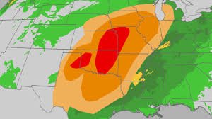
Friday’s Widespread Outbreak
Friday is anticipated to see a more expansive area of severe thunderstorms, extending from Texas to the upper Midwest. The NOAA Storm Prediction Center has issued a Level 3 severe weather outlook, indicating a high probability of numerous supercell thunderstorms capable of producing strong tornadoes (EF2 or greater) from northern Texas into southeast Nebraska and southern Iowa. Large hail, potentially baseball-sized or larger, and destructive winds are also concerns. Severe thunderstorms with hail are possible as far north as southern Minnesota and into the southern Great Lakes, including the Chicagoland area.
Affected Cities: Austin, Dallas, Oklahoma City, Tulsa, Kansas City, Omaha, Des Moines, Chicago, Madison, St. Louis
Looking Ahead: This Weekend and Beyond
The severe weather isn’t limited to Thursday and Friday. Saturday could bring strong to severe storms from the Ohio Valley and Appalachians to eastern and central Texas. Sunday may see isolated severe storms in parts of the South, along a stalling frontal boundary. Early to mid-next week, a strong cold front will push into the central and eastern U.S., bringing another round of severe thunderstorms, particularly in the Plains.
The NOAA Storm Prediction Center has already highlighted a renewed threat of severe storms for Tuesday, potentially impacting the same areas affected this week. Stay updated with the latest forecasts from weather.com and The Weather Channel app.
Flooding Concerns
Flash flooding is a significant concern alongside the severe thunderstorm threat. Parts of the Ohio Valley and Plains have already experienced flash flooding this week, requiring water rescues. Locally heavy rainfall is expected with each round of thunderstorms, potentially adding another 3+ inches of rain to areas from the Southern Plains into the Mississippi and Ohio valleys. This could exacerbate flooding, especially in eastern Texas, eastern Oklahoma, Arkansas, northern Louisiana, and the Ohio Valley.
The Role of La Niña
The current weather patterns are also influenced by the fading La Niña phenomenon. La Niña typically forces the jet stream northward, leading to warmer and drier conditions in the South. This pattern directs most precipitation and cooler temperatures to the northern regions. You can learn more about La Niña here.
Be Prepared: Ensure you have multiple ways to receive official National Weather Service watches and warnings, including nighttime alerts. Know your safe shelter location and seek it immediately when a warning is issued.


