
Phoenix Weather Update: A Mix of Warmth, Wind, and Potential Showers
Phoenix residents experienced a fluctuating weather pattern at the end of March, with warm temperatures, isolated showers, and gusty winds dominating the forecast. The National Weather Service (NWS) predicted these conditions would persist through March 30th before a noticeable cooling trend begins.
Record-Breaking Warmth
March 29th saw a record-warm low temperature at Phoenix Sky Harbor International Airport, reaching 72 degrees Fahrenheit – surpassing the previous record of 67 degrees set back in 1986. Daytime highs soared into the 90s across the lower deserts, nearing daily records for late March. Similar temperatures were anticipated for March 30th.
Isolated Showers and Weak Thunderstorms
While the overall weather pattern was warm, the possibility of isolated showers and weak thunderstorms existed, particularly south of the Phoenix metropolitan area, including southern Maricopa County and Pinal County. Meteorologist Chris Kuhlman of the NWS office in Phoenix noted that most storm activity would remain localized and relatively weak.
Due to the dry air near the surface, much of any rainfall was expected to evaporate before reaching the ground. This means that while showers were possible, significant rainfall was not anticipated.
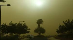
Gusty Winds and Blowing Dust
Gusty winds were a key feature of the weather pattern, especially along the Interstate 8 and Interstate 10 corridors on March 29th. Wind gusts of 30 to 40 mph were predicted, potentially creating areas of blowing dust. While the winds were expected to weaken as they moved into the metro area, a 10% to 20% chance of gusts exceeding 30 mph remained in Phoenix itself.
Blowing dust was a concern if stronger outflow winds developed, though the extent of the dust remained uncertain.
Cooling Trend on the Horizon
A welcome change is on the way! A cooling trend is expected to begin on March 31st as a weak weather system moves through the region. High temperatures are forecast to drop into the lower 90s on March 31st and further into the mid-80s by April 1st.
Rain chances will diminish significantly by April 1st as drier air moves into Arizona. While some isolated showers are possible in higher terrain on April 1st, the probability remains low, generally between 5% and 20%.
Stay Informed
For the latest updates on the Phoenix weather, please refer to the National Weather Service website. You can also find more information from local news sources like azcentral.com.
Source: Rey Covarrubias Jr., The Arizona Republic and azcentral.com


