
Chicago Weather Update: Brace for Severe Storms and a Dramatic Temperature Shift
CHICAGO, IL – The Chicago area is under siege by severe weather, with AccuWeather meteorologists issuing alerts for Monday night and Tuesday. Residents are urged to stay informed and prepared for potentially hazardous conditions.
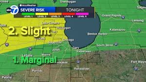
Current Warnings and Watches
As of late Monday, several warnings and watches are in effect:
- Severe Thunderstorm Warning: Cook and Lake (Indiana) counties until midnight Tuesday.
- Severe Thunderstorm Warning: Kane County until 11:45 p.m. Monday.
- Severe Thunderstorm Watch: Boone, Cook, DeKalb, Grundy, Kane, Kendall, LaSalle, Lake (Illinois), McHenry, Will, Racine, Walworth, and Kenosha counties until 3 a.m. Tuesday.
What to Expect: Hail, Wind, and Potential Tornadoes
According to ABC7 Chicago AccuWeather meteorologists Phil Schwarz and Cheryl Scott, these storms pose a significant threat. Expect strong winds capable of causing damage, large hail, and a low but present risk of tornadoes. Flooding is also a concern, particularly in areas experiencing heavy rainfall.
The first round of scattered, strong storms began impacting the Chicago area after 10 p.m. Monday, with areas north of the city facing the highest risk of severe weather.
Storm Timeline: Overnight Through Tuesday
More storms are anticipated overnight and into early Tuesday morning. A brief respite is expected during the day, but a second, potentially stronger round of storms is forecast to arrive after 4 p.m. Tuesday. The primary threat will then shift south of the city, with storms continuing through midnight.
Record-Breaking Heat Followed by a Cold Front
Monday afternoon saw temperatures soar to 80 degrees Fahrenheit, breaking the daily record of 79 degrees set in 1998. This marked the warmest day of the year so far. However, this warmth is short-lived. A cold front is moving in, and temperatures will plummet sharply late Tuesday.
Looking ahead, Wednesday’s temperatures are expected to be approximately 30 degrees colder than Tuesday’s highs.
Extended Forecast: More Rain on the Way
The unsettled weather pattern continues. Additional rain and storms are predicted for Thursday and again on Saturday. Stay tuned to ABC7 Chicago for the latest updates and detailed forecasts.
For more information on severe weather preparedness, visit the National Weather Service.


