
Winter Storm Warning: Charlotte Prepares for Major Snow Event
CHARLOTTE, N.C. – Charlotte residents are bracing for a significant winter storm poised to deliver the most substantial snowfall to the Queen City since January 17, 2018, when 3.9 inches blanketed the area. While January 2022 saw measurable snowfall – 2.2 inches on January 16th and 1.9 inches on January 21st – this upcoming storm is predicted to be far more impactful.
Current Forecast & Winter Storm Watch
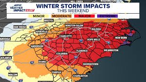
The WCNC Charlotte Weather Impact Team forecasts 3 to 6 inches of snow, with potentially higher accumulations east of the city. A Winter Storm Watch is currently in effect for the Charlotte area until Sunday, encompassing Alexander, Anson, Burke, Cabarrus, Caldwell, Catawba, Chester, Chesterfield, Cleveland, Gaston, Iredell, Lancaster, Lincoln, Mecklenburg, Richmond, Rowan, Stanly, Union, and York counties. Ashe, Watauga, Avery counties, as well as portions of Burke and Caldwell, have been upgraded to a Winter Storm Warning as of Thursday afternoon.
What to Expect: Dry Snow and Hazardous Conditions
This event is expected to bring “dry snow” – a powdery consistency prone to drifting. This type of snow accumulates quickly and can be easily blown around by the wind. Charlotte is currently anticipating 3-6 inches of snowfall from Saturday morning through Saturday evening.
Travel Impacts
- Immediate Snow Accumulation: Due to the preceding cold temperatures, snow will stick to road surfaces immediately, creating hazardous travel conditions throughout Saturday.
- Gusty Winds: Winds of 25-30 mph will contribute to blowing snow and reduced visibility.
- Black Ice Risk: Any melting during the day on Sunday will rapidly refreeze overnight, leading to widespread black ice on roadways.
Extreme Cold and Potential Infrastructure Issues
Lows in the teens on Sunday morning will match the coldest temperatures of the season so far. However, single-digit lows expected on Monday morning pose a significant threat. Burst pipes and water mains are a major concern across the region. The combination of snow and extreme cold creates a double-edged winter challenge.
Preparing Your Home & Family
Here’s how to prepare:
- Home Infrastructure: Drip faucets and leave cabinet doors open to prevent pipes from freezing. Have an alternative heating source available in case of power outages, but never use a grill or generator indoors.
- Travel Safety: Avoid unnecessary travel during the peak of the storm on Saturday. If travel is essential, keep a winter emergency kit in your vehicle, including blankets, water, and a flashlight (the 4 Ps – People, Pets, Plants, Pipes).
- People: Check on elderly neighbors and ensure everyone has adequate warmth.
- Pets: Bring all outdoor animals indoors; these temperatures are life-threatening for pets.
- Plants: Move sensitive plants indoors or wrap them heavily.
- Pipes: Insulate outdoor spigots and exposed plumbing.
Stay Informed
For constant updates, watch WCNC Charlotte and WCNC+. You can also follow Brad Panovich and the WCNC Weather Impact Team on their Emmy Award-winning Weather IQ YouTube channel.
Connect with the WCNC Weather Team:
- Brad Panovich: bpanovich@wcnc.com, Facebook, X, Instagram
- Bekah Birdsall: rbirdsall@wcnc.com, Facebook, X, Instagram


