
Weather in London, Ontario: A Warm But Wet Week Ahead
London, Ontario, and much of southern and eastern Ontario are in for a rollercoaster of weather this week. While residents can look forward to unseasonably warm temperatures nearing 20°C, this warmth will be accompanied by gusty winds, moisture-fueled storms, and a significant chance of heavy rainfall. It’s a good time to dust off those umbrellas!
What to Expect This Week
A surge of warm, southerly air is dominating the region, bringing temperatures more typical of late May than mid-April. However, this warmth isn’t coming without its challenges. Strong southwesterly winds, gusting up to 60 km/h, will be prevalent, alongside moisture-rich systems drawing energy from the Gulf of Mexico. The clash between this warm air and colder air pushing in from the north is creating an active storm track across southern Ontario.
Here’s a day-by-day breakdown:
- Monday Night: Thunderstorms from the U.S. are expected to cross Michigan overnight, potentially impacting areas near Lake Huron by Tuesday morning.
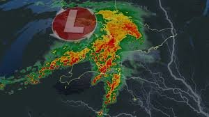
- Tuesday: Early morning thunderstorms will move through southwestern Ontario and the Greater Toronto Area (GTA), potentially disrupting commutes. Expect heavy downpours, frequent lightning, and the possibility of small hail. Rainfall totals could reach 30-50 mm in areas like Goderich, London, and Sarnia, with 20-30 mm anticipated for the GTA and Niagara.
- Wednesday: The stormy pattern continues, with overnight storms originating in Michigan progressing into southern Ontario. The afternoon remains uncertain, with a warm front potentially triggering further thunderstorm development, particularly in areas like Windsor, Lake Erie, and London.
- Thursday: Warm, elevated showers and thunderstorms are expected to persist as the warm front shifts northward. Temperatures will consistently remain 10°C above seasonal norms.
Rainfall Amounts: Some areas could see a substantial 50-100 mm of rain throughout the week. Special weather statements and yellow-coded rainfall warnings are currently in effect. Be prepared for potential pooling of water on roads and in low-lying areas. Never drive through flooded roadways.
A Look at the Bigger Picture
Toronto’s Pearson International Airport is forecast to experience five or six consecutive days near 20°C this week, significantly exceeding the typical April average of fewer than three days above that temperature. Interestingly, mid-April 2023 saw even more intense warmth, reaching a high of 29.4°C on April 12th.
Forecasters are also keeping a close eye on a developing El Niño pattern this summer, which could have broader implications for weather conditions across Canada.
Stay tuned to The Weather Network for the latest forecast updates across southern Ontario. They are Canada’s #1 most trusted weather brand and news source* (*2026 BrandSpark® Canadian Trust Study & 2026 Pollara Trust in Media Study).


