
National Weather Service Issues Severe Weather Alerts for Central US
A relentless week of dangerous weather has descended upon the Central United States, beginning with multiple tornadoes and exceptionally large hail impacting parts of four states on Monday. This marks the start of several rounds of severe thunderstorms poised to threaten the region through Friday, according to the National Weather Service.
Tornadoes and Severe Storms Erupt Across the Midwest
Tornado activity intensified early Monday evening, with confirmed touchdowns in eastern Kansas, northern Iowa, southern Minnesota, and northern Wisconsin. The storms weren’t limited to tornadoes; nearly softball-sized hail pummeled areas south of Minneapolis, while severe winds toppled power lines and trees in northeast Illinois.
Widespread Threat Zone
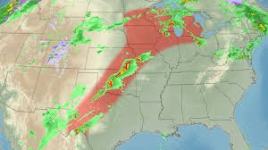
Approximately a dozen states, stretching from Texas to the Upper Midwest and the Great Lakes, are facing a threat of severe storms on one or more days this week. The specific areas at risk will shift daily, influenced by the interplay between surges of jet stream energy and warm, humid air – a recipe for intense thunderstorm development.
Flooding Concerns Escalate
The continuous barrage of storms is also raising significant flooding concerns, particularly in northern Michigan and northern Wisconsin, where rivers are already swollen from recent rainfall. Flash flood warnings are in effect for millions.
Damage Reports from Kansas and Beyond
Monday’s most intense storms resulted in several tornadoes in eastern Kansas, causing significant damage. In Linn County, Kansas, multiple buildings were reportedly “demolished,” according to emergency management director Randy Hegwald. A lake community southeast of Mound City sustained a direct hit, though thankfully, only minor injuries have been reported. Further north, in Hillsdale, Kansas, a tornado impacted dozens of homes, resulting in one minor injury. Emergency officials are working to provide shelter for displaced residents.
Structural damage was also reported in Ottawa, Kansas, leaving much of the town without power. Senator Jerry Moran urged residents to heed warnings from weather officials.
What to Expect: Large Hail, Strong Winds, and Potential Tornadoes
The primary concern moving forward is the potential for large hail, capable of damaging vehicles, shattering windshields, and causing roof damage. The storms may also produce additional tornadoes and winds strong enough to down trees and disrupt power lines.
Tuesday: Peak Threat of Severe Storms
Tuesday is anticipated to see the most widespread severe storm activity, with a threat zone extending from West Texas through Oklahoma and into the Great Lakes region. Cities like Chicago, Milwaukee, and Des Moines, Iowa, are under a Level 3 of 5 risk, impacting over 14 million people.
Supercell thunderstorms could develop, producing damaging hail the size of limes or larger. A few strong tornadoes (EF2 or higher) are also possible. Strong winds capable of knocking out power and uprooting trees are expected to accompany the storms as they move eastward.
Wednesday and Friday: Continued Threat
Wednesday is expected to bring another round of strong storms, though the intensity may be affected by Tuesday’s lingering storms. Wind damage and hail remain the biggest concerns. Another surge of jet stream energy is forecast to trigger a final round of potent thunderstorms on Friday, particularly from Oklahoma to Iowa, but the extent of the threat remains uncertain.
Weekend Relief and Flood Warnings
The storm-weary Central US is expected to finally experience a respite over the weekend as a change in the weather pattern brings cooler temperatures. However, flood watches remain in effect for over 3.5 million people across northern Wisconsin and Michigan, with multiple rounds of rainfall potentially exacerbating existing river flooding.
Flash Flood Warnings and Evacuation Concerns
Flash flood warnings are currently in effect for over 1 million people, including residents of Green Bay, Wisconsin, and Traverse City, Michigan. Significant street flooding has already stranded vehicles and closed roads in central Wisconsin. Authorities are urging residents near the Cheboygan County Lock and Dam in Michigan to prepare for potential evacuations due to rising water levels. Similar warnings are in place for the Tippy Dam and Mio Dam in northern Michigan, and the Muskegon River near Evart is forecast to reach major flood stage by Wednesday.
Stay informed by monitoring updates from the National Weather Service and local authorities.


