
KCRG Weather Update: Tornado Watch in Effect for Polk County and Beyond
Polk County, along with over three dozen other counties across Iowa, is currently under a tornado watch until 8 p.m. Thursday. Residents are urged to stay informed and prepared as multiple rounds of thunderstorms move across the state, with even more severe weather anticipated on Friday. Stay tuned to KCRG Weather for the latest updates.
Understanding Severe Weather Threats
Thursday afternoon brings a heightened risk of severe thunderstorms. It’s helpful to understand the potential hazards. Traditionally, hail size is described using common objects for reference – think peas, golf balls, and softballs. This visual aid can help you gauge the severity of incoming hail.
Crucially, ensure your mobile phone is set up to receive severe weather alerts. The U.S. Department of Homeland Security recommends checking your phone’s settings and enabling “Government Alerts” or “Emergency Alert Messages.” Don’t be caught off guard!
Stay Connected with the KCCI App
You can track the weather wherever you are with the KCCI app:
The app provides real-time weather alerts and live radar tracking directly on your phone.
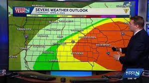
Thursday’s Storm System: What to Expect
Earlier today, central Iowa received over an inch of rainfall, keeping temperatures relatively cool. However, a surge of warmer air is moving into southern Iowa, providing fuel for additional thunderstorm development. These storms are currently forming in southwest Iowa and will quickly track eastward throughout the afternoon.
As these storms interact with the warm, humid air south of I-80, they are expected to intensify. The primary threats are large hail and damaging winds, with a lower, but still present, risk of tornadoes, particularly over southeastern Iowa where temperatures will have more time to rise.
The line of storms is anticipated to reach the I-35 corridor between 1 and 2 p.m. While the storms may not be severe upon reaching I-35, they will strengthen as they move eastward. By 5 p.m., the line should be moving out of central Iowa, diminishing the severe weather risk. Eastern Iowa may experience continued risk for a couple of hours before cooler, calmer weather settles in.
Friday’s Forecast: Increased Severe Potential
Another low-pressure system will bring warm, humid air into Iowa on Friday afternoon. Storms are expected to develop later in the afternoon in southern Iowa and northern Missouri. The severe potential is higher on Friday due to increased energy in the atmosphere and more favorable wind conditions.
The highest threat area is across southern and southeast Iowa, where storms will spread through into the evening. The key factor will be how quickly and how far north the warm, moist air lifts. Areas that remain cool throughout the day will have a significantly reduced or nonexistent severe weather risk.
Safety Guidelines During a Tornado Watch/Warning
If you are in a home, small building, nursing home, hospital, factory, shopping center, or high-rise building: Seek shelter in an interior room on the lowest level.
If you are in a mobile home, manufactured office building, or camper: Evacuate immediately and seek shelter in a sturdy building.
If you are not in a sturdy building: Lie flat in a ditch or other low-lying area and cover your head. (Note: This is a last resort, as it does not guarantee safety.)
Understanding the Enhanced Fujita (EF) Scale
The National Weather Service uses the Enhanced Fujita Scale (EF Scale) to rate tornadoes based on estimated wind speeds and damage. This scale categorizes tornadoes by the degree of damage and associates that damage with estimated wind speeds.
Disclaimer: Hearst Television participates in various affiliate marketing programs, which means we may get paid commissions on editorially chosen products purchased through our links to retailer sites.


