
Dallas Weather Update: Severe Storms and Tornado Watch in North Texas
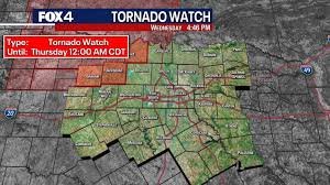
Dallas and surrounding areas are bracing for potentially severe weather, with a Tornado Watch issued for parts of North Texas. Residents in Jack, Montague, and Young County are under the watch until midnight, and these storms are expected to move into the Dallas-Fort Worth (DFW) area overnight. It’s crucial to stay informed and prepared as conditions can change rapidly.
What to Expect: Potential Hazards
The National Weather Service (NWS) warns of several potential hazards, including:
- High Winds: Strong gusts could cause damage to trees and property.
- Large Hail: Hail can cause significant damage to vehicles and structures.
- Flooding: Heavy rainfall may lead to localized flooding.
- Isolated Tornadoes: While the risk is lower, the possibility of tornadoes cannot be ruled out.
FOX 4 Weather Meteorologist Dan Henry provides ongoing updates on the developing situation. Check the latest forecast on FOX 4 News.
Timing and Forecast Details
A dryline to the west is triggering storm development, with storms expected to push eastward throughout the night. Current models suggest the storms will move through the Metroplex between 1 a.m. and 5 a.m. Thursday. While the tornado threat is currently low, vigilance is key.
The severe weather is expected to return Wednesday evening, with large hail and damaging winds as the primary threats. Thursday morning will see the line of storms continuing eastward, with a lull in activity expected by the afternoon.
Looking Ahead: Weekend Weather Outlook
Another round of active weather is anticipated to arrive Friday evening, becoming widespread Friday night and lasting into Saturday. This system also carries the risk of large hail, damaging winds, and localized flooding. While the exact timing remains uncertain, heavy rain is expected to linger through much of Saturday.
A cold front will sweep across the area from northwest to southeast on Saturday afternoon, bringing noticeably cooler and drier air. Expect low temperatures in the 40s and 50s late Saturday. The rain should taper off by Saturday night, setting the stage for a mostly dry and pleasant Easter Sunday with highs in the mid- to upper 60s. A slight chance of rain may persist for areas south of the Metroplex.
Stay Updated
For the latest information and updates on the Dallas weather, please refer to the following resources:
Source: Information provided by the National Weather Service and FOX 4 meteorologists.


