
Weather Winter Storm Warning: Twin Cities Braces for Treacherous Conditions
The Twin Cities are bracing for a significant winter weather event, with a mix of freezing rain, sleet, and snow expected to create hazardous travel conditions Wednesday night and Thursday morning. FOX 9’s Ian Leonard has the latest forecast, urging residents to prepare for a challenging commute.
Hazardous Travel Conditions Expected
A treacherous commute is anticipated on Thursday morning as rain, snow, ice, and sleet combine to create slick and dangerous roadways. The potential for icy surfaces during the morning commute is high, and drivers are advised to exercise extreme caution.
Forecast Breakdown
Wednesday will begin relatively quiet across Minnesota, with increasing cloud cover throughout the day. Temperatures will hover in the mid-40s, slightly below average, accompanied by a light northeast breeze. While most of the day will remain dry, isolated showers may develop in western Minnesota by late afternoon.
The real change in conditions arrives after sunset, as a weather system moves in, bringing a complex mix of precipitation.
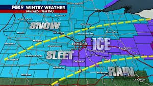
Timeline of the Storm
Here’s a detailed timeline of what residents in the Twin Cities metro area can expect:
- Wednesday Evening: Conditions begin to deteriorate as precipitation increases.
- Overnight: A mix of freezing rain, snow, and ice develops, creating hazardous conditions.
- Thursday Morning: Slick surfaces and dangerous travel conditions are expected during the commute.
- Thursday Afternoon: Conditions may gradually improve, but caution is still advised.
The National Weather Service has issued a winter weather advisory for much of Minnesota from midnight through Thursday. A more severe winter storm warning is in effect for the Twin Cities metro area and the Arrowhead region until noon Thursday, due to the potential for heavier mixed precipitation and significantly hazardous travel.
Looking Ahead: More Weather on the Way
The wintry mix isn’t the end of the story. Another system is expected to follow closely behind, bringing additional chances for rain and potentially snow from Friday into Saturday. Sunday offers a glimmer of hope, with colder but quieter conditions and the return of sunshine. Temperatures will remain slightly below average heading into early next week.
Seven-Day Forecast
(Refer to FOX 9 for the detailed seven-day forecast: https://www.fox9.com/weather)
Source: This report is based on information provided by FOX 9 meteorologists. Stay informed and prioritize safety during this winter storm.


