
Severe Storms Threaten Parts of the US
Another significant severe weather outbreak is forecast to impact the South, Midwest, and East, including areas still recovering from last week’s damaging storms. The National Weather Service has already confirmed at least 18 tornadoes from Thursday through Saturday, stretching from Texas to Michigan, tragically including four killer tornadoes – two each in Michigan and Oklahoma. This week brings a second chapter of potentially dangerous weather.
Current Forecast: Day-by-Day Breakdown
Monday
The primary severe weather threat on Monday focuses on parts of Arkansas, Louisiana, Mississippi, and Alabama. While strong wind gusts, tornadoes, and localized flooding are possible, the main concern is large hail, potentially golf ball size or larger.
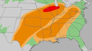
Tuesday
Tuesday afternoon and evening pose the highest tornado threat, particularly in Texas and the Midwest. Severe thunderstorms are expected to develop in the Southern Plains, with the potential for hail larger than golf balls and tornadoes. Later in the day, these storms are anticipated to become more widespread across the Mississippi Valley and western Great Lakes, from Missouri and southeast Iowa to Illinois, northern Indiana, and southern Michigan. The risk includes tornadoes (some potentially EF2 or stronger), large hail, and damaging wind gusts. This threat could persist overnight from the western Great Lakes to Texas, accompanied by localized flooding.
Wednesday
Wednesday’s main threat shifts to damaging thunderstorm wind gusts across the Appalachians, interior Northeast, and lower Mississippi Valley. However, a few tornadoes remain possible, along with locally heavy rainfall. Thunderstorms, some potentially severe, will continue into the night from the Tennessee Valley to the northern Gulf Coast.
Thursday
At least a few severe thunderstorms are possible near the Southeast coast and Florida on Thursday as a cold front moves through. (See the 7-Day US Rain/Snow Forecast for a broader view.)
Heavy Rainfall & Flooding Concerns
Alongside the severe storm threat, heavy rainfall is expected. Many areas already experienced significant rainfall last week, meaning the ground is saturated. An additional 1-3 inches of rain is possible, with higher totals anticipated where slow-moving storms repeatedly impact the same locations.
Safety Tips for Severe Thunderstorms
- Stay Informed: Have multiple ways to receive official watches and warnings from the National Weather Service, including your smartphone and a NOAA weather radio. Ensure both are fully charged and notifications are enabled.
- Plan Your Shelter: Before a storm approaches, identify the safest place to take shelter in your home or community. If you live in a manufactured home, know the location of the nearest community shelter or a sturdy nearby building.
- Take Immediate Action: When a warning is issued, seek shelter immediately – for both severe thunderstorm and tornado warnings. Don’t delay to look outside; tornadoes can be hidden by rain or invisible at night.
(Learn more about severe weather preparedness: National Weather Service Severe Weather)
The Weather Channel is recognized as the world’s most accurate forecaster, according to ForecastWatch, Global and Regional Weather Forecast Accuracy Overview, 2021-2024, commissioned by The Weather Company.


