
Weather Winter Storm Warning: California Braces for Coldest Storm of the Season
California is preparing for its coldest storm of the season, arriving this Sunday and lasting through at least Wednesday, potentially extending into Thursday. This system promises a significant influx of much-needed mountain snow, particularly in the Sierra Nevada, but also carries the risk of flooding rain across parts of the state and the Southwest.
A Strange Winter for the West
This winter has been remarkably unusual for the Western United States. Record-breaking warmth dominated the region for an extended period, accompanied by a severe lack of precipitation. This created a concerning situation, especially regarding the region’s snowpack, which was at record lows for this time of year, stretching from the Pacific Northwest to the Southern Rockies.
The Shift in Weather Patterns
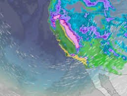
Fortunately, the warm and dry pattern is finally breaking down. A shift in the jet stream is responsible for this change, bringing cooler temperatures, rain, and, crucially, mountain snow. While beneficial overall, the intensity of the precipitation raises concerns about potential flooding, particularly in areas affected by recent wildfires (burn scars). The areas highlighted in darker green and yellow on weather maps indicate the highest probability of heavy rainfall during this prolonged wet period, encompassing coastal and Southern California, as well as the Sierra foothills at lower elevations.
Snowpack Boost and Travel Impacts
The Sierra Nevada snowpack is expected to receive a substantial boost, with several feet of snow anticipated next week. While this is welcome news, it will undoubtedly create challenging, and potentially impassable, travel conditions in higher elevations. Currently, the California Department of Water Resources reports the snowpack is only about 55% of average for this time of year. This storm is vital for replenishing this critical resource.
The jet stream’s southward plunge into the West is the key driver of this change. Historically, the jet stream has been riding far north into Canada, leading to warmer temperatures and less precipitation in the West. This shift will bring the much-needed moisture and cooler temperatures.
Why Snowpack Matters
The snowpack in the Western United States isn’t just important for recreational activities like skiing and snowboarding. It serves as a crucial freshwater source during the drier months. The lack of snowfall this winter has been a significant concern, as the West heavily relies on this natural reservoir. According to the National Resources Conservation Service, numerous locations across Colorado, Utah, and the Pacific Northwest are experiencing snowpack levels that are the lowest in at least a decade. Colorado, in particular, is facing record-low snowpack, requiring substantial snowfall just to reach normal levels. USDA/NRCS
Stay Informed
Stay updated on the latest forecasts and warnings from reliable sources like The Weather Channel. Be prepared for potential travel disruptions and flooding, and take necessary precautions to ensure your safety.
Rob Shackelford is a meteorologist and climate scientist at weather.com.


