Unveiling the Depths: The Enigmatic Blue Hole of Taam Ja’
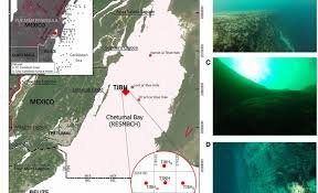
From the surface, Chetumal Bay appears tranquil – a vast expanse of water concealing a hidden world below. Beneath the calm lies Taam ja’, a colossal underwater sinkhole, or “blue hole,” that has become an unexpected focal point for scientific investigation. What began as a straightforward mapping project has quickly evolved into a captivating mystery.
The Challenge of Mapping the Unknown
Initial plans to map Taam ja’ using sonar quickly hit a snag. Early readings suggested a depth far shallower than anticipated, prompting a crucial question: could the true depth be significantly greater? Recent measurements indicate a hole that plunges far deeper than originally estimated, with the actual bottom remaining elusive.
Blue holes serve as natural laboratories, often connecting to subterranean cave systems. They also accumulate layers of sediment over time, preserving valuable clues about past storms, climate shifts, and sea-level changes. However, before researchers can delve into these broader questions, they must first establish the fundamental characteristics of the hole: its shape and its true depth.
Sonar’s Limitations and the Rise of CTD Profiling
Early sonar mapping estimated Taam ja’ to be approximately 900 feet (274 meters) deep. While sonar typically relies on sending sound waves and measuring their return time, blue holes present unique challenges. Variations in water temperature and salinity can bend or scatter sound waves, leading to inaccurate readings. Slanted walls or irregular features can also cause premature signal returns, creating the illusion of a shallower bottom.
Furthermore, blue holes rarely form as smooth, straight tubes. They often tilt, narrow, expand into chambers, or branch into side passages. This complex geometry can cause a device lowered from above to deviate from a straight path, potentially missing the deepest point.
To gain a more accurate understanding of the upper portion of Taam ja’, divers explored the opening to a depth of about 98 feet (30 meters). They observed that the walls weren’t uniform, with some areas appearing soft and fragile, coated with biofilms – thin, slimy microbial layers. As they descended, the walls became steeper, the rock firmer, and the coatings less prominent.
Recognizing the limitations of sonar in this complex environment, the research team turned to a CTD profiler. CTD stands for conductivity, temperature, and depth. Conductivity estimates salinity, temperature is measured directly, and depth is calculated from pressure. Pressure-based depth measurements are far more reliable than sonar echoes when acoustic conditions are challenging.
Unveiling the Depths with CTD Technology
During two expeditions in December 2023, the team anchored a boat over the hole and lowered the CTD on a cable approximately 1,640 feet (500 meters) long. However, the depth readings consistently fell short of the cable length, indicating that the instrument wasn’t descending in a straight line – currents and the hole’s internal structure likely caused it to drift sideways.
Despite these challenges, the results were remarkable. On one day, the CTD reached a depth of about 1,365 feet (416 meters) below sea level, and on another, it reached 1,390 feet (423.6 meters) – still without reaching the bottom. This confirms that Taam ja’ is deeper than 1,390 feet, and its true depth remains unknown.
Layered Waters and Potential Connections
The CTD also revealed that the water within Taam ja’ is strongly layered, with several pycnoclines – thin bands where water density changes rapidly. These density boundaries resist mixing, allowing the water above and below to remain separated for extended periods. Near the surface, conditions resembled those of an estuary, with warmer, less saline water typical of a partly enclosed bay receiving freshwater from land.
As the CTD descended, temperature generally decreased and salinity increased, but not smoothly. Instead, the changes occurred in steps, marking sharp boundaries between layers. Below about 1,300 feet (400 meters), the trend reversed, with temperature rising slightly and salinity climbing even higher, suggesting a different water source.
Comparing the measurements to nearby regional waters, the upper layers aligned with the bay’s mixed, lower-salinity water. However, the deepest measured layers exhibited characteristics more typical of Caribbean marine water. While this doesn’t definitively prove a direct connection to the Caribbean Sea, it supports the idea that the deepest water originates from beyond the bay.
Geological Context and Future Research
The region’s geology lends plausibility to this complexity. The Yucatán Peninsula is largely composed of limestone, which dissolves over time, forming voids and cave networks. Past sea-level changes have flooded these underground spaces, creating systems where freshwater and seawater can interact in intricate ways.
The next step is to create a detailed 3D model of Taam ja’s interior and, if possible, confirm its bottom depth. With this groundwork in place, researchers can investigate the stability of the layers, the changes in oxygen and other chemicals with depth, and the types of microbial communities that can survive in this isolated environment.
For now, Taam ja’ remains partly defined by what we don’t know. Its depth exceeds 1,390 feet, and its bottom remains undiscovered. These facts will shape future dives, equipment choices, and sampling strategies. If deeper water is indeed entering the blue hole from elsewhere, and if the layers remain separated, then Taam ja’ is not merely a deep pit, but a connected, structured, and active system that researchers are only beginning to understand.
The full study was published in the journal Frontiers in Marine Science.