
Severe Weather Alert: Southern Ontario Under Yellow Watch for Thunderstorms
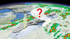
Residents across Southern Ontario should brace themselves for a volatile weekend. A yellow watch for severe thunderstorms has been signaled as an active weather system pushes across the Great Lakes, bringing the potential for widespread and intense storm activity this Saturday.
While the forecast remains complex due to several atmospheric variables, the risk of severe weather is significant enough to warrant caution for anyone planning outdoor activities.
What to Expect: The Primary Threats
As a cold front approaches the region, the atmosphere is expected to become highly unstable. According to meteorological data, the most severe storms could bring the following risks:
- n
- Frequent Lightning: High electrical activity is expected throughout the affected zones.
- Damaging Winds & Hail: Strong wind gusts and large hail could pose a threat to property and vehicles.
- Localized Flooding: Intense rainfall over short periods may lead to flash flooding in urban and rural areas.
- Tornado Potential: There is a risk of embedded rotation, which could produce brief but dangerous tornadoes, particularly where the storm line interacts with lake breezes from Lake Erie and eastern Lake Ontario.
Timing and Affected Regions
The weather pattern is expected to evolve throughout the day. Early morning showers will likely clear out of Southern Ontario by mid-morning as a warm front moves north into Quebec. However, the threat will ramp up significantly during the afternoon hours.
High-risk areas include:
- n
- The corridor from London to Cornwall.
- Prince Edward County, stretching from Cobourg to Kingston.
- The region from St. Mary’s to Lake Erie.
The Wildcards: Wildfire Smoke and Stable Air
Forecasters are noting two main factors that introduce uncertainty into this Saturday’s outlook. First, the lingering presence of thick wildfire smoke can act as an inhibitor, potentially capping the intensity of thunderstorm development.
Secondly, rain-cooled air from Friday night may create a layer of stability, especially in eastern Ontario east of the Kawarthas, which could hamper the severity of the storms. Despite these mitigating factors, the high levels of shear, helicity, and CAPE (Convective Available Potential Energy) mean that severe weather cannot be ruled out.
Stay Safe and Informed
When a severe thunderstorm risk is present, the best course of action is to stay informed and have a safety plan in place. We recommend monitoring official updates from Environment Canada to receive real-time alerts and warnings.
Keep a battery-powered radio handy, secure loose outdoor objects, and seek shelter in a sturdy building immediately if a tornado warning is issued for your specific area.



