
Weather Update: Preparing for Heatwaves and Tropical Disturbances
As we move through the peak of summer, the atmosphere is becoming increasingly unpredictable. With temperatures soaring and tropical activity stirring in the Pacific, staying informed is key to your safety and comfort. Whether you are planning your commute or an outdoor activity, here is a comprehensive look at the upcoming weather patterns based on the latest meteorological models.
The Immediate Outlook: Thunderstorms and High Heat (July 17–21)
Recent data from the European Centre for Medium-Range Weather Forecasts (ECMWF) indicates a period of atmospheric instability. While tropical cloud clusters in the South China Sea are currently lacking the ideal conditions for major development, they are playing a crucial role in pushing moisture-laden southwest winds toward the region.
What to expect between July 17 and July 21:
- n
- Intense Heat: Highs have recently hit around 37°C, with overnight lows hovering between 23°C and 24°C.
- Afternoon Thunderstorms: Due to the weak Pacific High, strong convection is likely to develop in mountainous areas and spread to the plains.
- Weather Alerts: Be vigilant regarding sudden heavy rainfall, lightning strikes, and strong wind gusts during afternoon storms.
Pro Tip: Before the rain hits, the heat can be oppressive. We strongly recommend using high-SPF sunscreen and staying hydrated to prevent heatstroke.
Looking Ahead: A Return to Stable, Sunny Skies (July 21–26)
Starting next Wednesday, July 21, we expect a shift in the weather pattern. The low-level southwest winds will weaken, and the moisture supply from the south will decrease. Simultaneously, the Pacific High is expected to strengthen, leading to more stable atmospheric conditions.
From July 21 to July 26, you can expect:
- n
- Clear Skies: Most regions will experience sunny and bright days.
- Persistent Heat: While the rain decreases, the heat remains. Daytime temperatures will stay high, making sun protection essential.
- Isolated Showers: There remains a slight chance of brief, localized showers in mountainous regions during the afternoons.
Tropical Activity: The Short-Lived Storm Near Guam
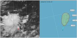
Meteorologists are closely monitoring a tropical depression located southeast of Guam. According to infrared cloud imagery and path potential maps, the system currently possesses a loose structure and unfavorable development conditions.
While there is a possibility that this system could briefly intensify into a typhoon by July 17, it is expected to move northward and weaken back into a tropical depression by July 18. In short, this is projected to be a short-lived weather event with minimal long-term impact.
How to Stay Safe During Extreme Summer Weather
To ensure your well-being during these fluctuating conditions, follow these guidelines provided by global health and weather authorities like the World Meteorological Organization (WMO):
- Hydration: Drink plenty of water, even if you don’t feel thirsty.
- Timing: Limit outdoor activities during the peak sun hours (11 AM to 4 PM).
- Shelter: If a thunderstorm begins, move indoors immediately to avoid lightning risks.
- Monitoring: Keep an eye on local weather apps for real-time warnings.
Stay safe, stay cool, and keep an eye on the skies!



