
Urgent Weather Alert: Tornado Warning in Iowa and Nebraska
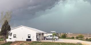
A volatile cold front swept through the Midwest this afternoon, triggering a series of dangerous weather events. From confirmed tornadoes in Iowa to destructive hail in Nebraska, the region has been under high alert as severe storms rolled through, leaving residents scrambling for shelter.
The Situation in Iowa: Confirmed Tornadoes
The most critical updates emerged from southwest Iowa. Law enforcement confirmed a tornado on the ground near Riverton, Iowa, located in Fremont County. The storm’s trajectory created significant danger for nearby towns, including Farragut, Shenandoah, and Essex.
The National Weather Service (NWS) issued several urgent alerts, including:
- n
- Page County: A tornado warning was in effect until 7:00 p.m., following radar-indicated threats.
- Fremont County: Immediate shelter was urged for residents as the Riverton tornado moved eastward.
- Flash Flood Warnings: Montgomery and Pottawattamie counties faced severe flooding risks, with warnings active until late evening.
Nebraska Under Siege: Baseball-Sized Hail and High Winds
The instability wasn’t limited to Iowa. Nebraska experienced a chaotic afternoon with several Tornado Warnings across Nemaha, Otoe, and Johnson counties. Residents were warned of not only rotating storms but also destructive hail, with some reports indicating stones as large as baseballs.
In the metro area, Eppley Airfield reported flight delays, and severe thunderstorm warnings hit Douglas, Sarpy, and Washington counties, with damaging winds reaching at least 60 mph.
Safety First: What to Do During a Tornado Warning
When a tornado warning is issued, every second counts. According to Ready.gov, the best course of action is to:
- Go Indoors: Find a sturdy building immediately.
- Move to the Lowest Level: A basement or storm cellar is ideal.
- Put Put Walls Between You and the Storm: If no basement is available, go to an interior room on the lowest floor (like a closet or bathroom).
- Avoid Windows: Stay away from glass to prevent injuries from flying debris.
Looking Ahead: Weekend Forecast
While the immediate threat of the cold front diminishes as it moves east, the weather remains unpredictable. Dew points are expected to drop tonight, bringing more comfortable air by Friday. However, residents should stay vigilant, as more scattered showers and potential storms are forecasted for Saturday afternoon and Sunday.
Stay tuned to local weather authorities and keep your emergency kits ready.


