
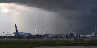
The Rise of a Super El Niño: What You Need to Know
Weather patterns are shifting rapidly, and the latest El Niño weather forecast is sending warning signals to travelers and homeowners alike. A “Super El Niño” is currently intensifying in the Pacific Basin, promising a volatile climate cycle that could significantly alter weather conditions across North America and beyond.
But what exactly is this phenomenon, and why should you care? El Niño is one of the three phases of the El Niño-Southern Oscillation (ENSO). This natural cycle involves temperature fluctuations in the central Pacific Ocean, which in turn trigger a domino effect on global atmospheric circulation, leading to unpredictable weather events.
NOAA Confirms: A Historically Strong Event is Underway
According to recent data from the National Oceanic and Atmospheric Administration (NOAA), we are witnessing a rapid surge in water temperatures across the Central and Pacific basins. The statistics are staggering:
- n
- 81% Probability: There is a high chance that this could become one of the strongest El Niño events on record.
- 97% Certainty: Forecasters predict that these conditions will persist throughout the upcoming winter and well into the spring.
This intensification coincides with the peak of the Atlantic Hurricane Season and the onset of the Southwest monsoon season, creating a complex atmospheric cocktail that could lead to increased storm activity.
How the El Niño Weather Forecast Impacts Your Travel
If you are planning a road trip or a flight between August and March, you need to be prepared. The defining characteristic of a classic Super El Niño is a highly energized subtropical jet stream. This atmospheric “river” locks into place across the southern tier of the United States, shifting the storm track directly over key regions.
High-Risk Zones for Travel Delays
Expect increased frequency of severe weather, heavy rainfall, and potential flight cancellations in the following areas:
- n
- The Southern Plains: Increased volatility and storm frequency.
- The Gulf Coast: Higher risk of flooding and severe tropical activity.
- The Eastern Seaboard: A direct path for winter storms and heavy precipitation.
While some regions may only experience near-average rainfall, those in tropical climates or the southern U.S. should anticipate significant disruptions to their itineraries.
Tropical Activity and the Pacific Basin
The influence of El Niño extends far beyond the U.S. mainland. Historically, these conditions favor above-average tropical activity in the Eastern Pacific. On average, this basin produces 15 named storms and 8 hurricanes annually, with several reaching Category 3 or stronger. With the current intensification, the window for storm development is widening, making it crucial to monitor World Meteorological Organization updates.
Final Tips for Navigating the Season
To avoid the wrath of a Super El Niño, we recommend the following:
- Stay Flexible: Book refundable flights and hotels if traveling to the Southern or Eastern U.S. during winter.
- Monitor Local Alerts: Keep a close eye on real-time weather updates to avoid flash flooding areas.
- Plan Alternatives: Consider destinations outside the subtropical jet stream path to ensure a smoother vacation.
As the climate continues to evolve, staying informed is your best defense against the unpredictability of the Super El Niño.



