
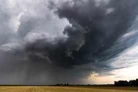
Severe Thunderstorm Yellow Watch: Why Southern Saskatchewan is Seeing More Storms This Summer
Residents of Southern Saskatchewan have noticed a significant shift in weather patterns this season. With an active stretch of severe thunderstorm activity, many have been keeping a close eye on the yellow watch alerts to stay prepared. But what exactly is driving this sudden surge in atmospheric volatility?
According to experts from Environment and Climate Change Canada, a unique combination of environmental factors has converged to create the perfect storm—literally.
The Science Behind the Storms: Moisture and Recovery
Meteorologist Chloe Katsademas explains that the Prairies have seen a more consistent storm track this year, bringing a substantial increase in moisture compared to previous seasons. This shift is closely tied to the region’s recovery from previous drought conditions.
In the past, extreme dryness on the surface often acted as a deterrent, diminishing both the frequency and the intensity of thunderstorms. However, as Saskatchewan and Manitoba recovered from these droughts throughout the winter and spring, the environment became far more conducive to storm development.
Key Factors Fueling Current Weather Patterns:
- Increased Surface Moisture: Higher humidity levels provide the necessary fuel for storm clouds to grow.
- Drought Recovery: A moist surface prevents the “damping” effect that usually limits storm intensity.
- Atmospheric Energy: A more consistent storm track ensures a steady flow of instability across the region.
The Surprising Impact of Wildfire Smoke
One of the most interesting variables this year is the reduction in wildfire smoke across Western Canada. While smoke may seem unrelated to rain, it plays a critical role in temperature regulation.
Katsademas notes that heavy smoke cover can act as a shield, reducing surface temperatures and limiting the thermal energy required for thunderstorms to develop. With less smoke in the air this season, the ground has warmed more effectively, providing the energy boost needed for severe weather to trigger more frequently.
What This Means for Your Safety
The combination of high moisture and increased surface heat doesn’t just mean more rain; it increases the potential for dangerous weather events. When a severe thunderstorm develops, the risks include:
- Strong Winds: Capable of causing structural damage and knocking out power lines.
- Heavy Hail: Which can damage crops and vehicles.
- Flash Flooding: Due to the intense moisture load in the atmosphere.
Despite these known factors, meteorologists warn that predicting the exact location and intensity of individual cells remains a challenge. This is why staying tuned to local alerts and maintaining a state of readiness during a yellow watch is essential.
Community Corner: Staying Active in Moose Jaw
While the weather can be unpredictable, community spirit remains high. For those looking to beat the heat between storms, the Co-op Community East End Spray Park is a fantastic spot for family fun. Additionally, for those interested in local infrastructure, the City of Moose Jaw continues to optimize roadway paving management under the guidance of Director of Operations, Bevan Harlton, ensuring the city remains accessible regardless of the season.



