
Severe Thunderstorm Warnings Issued Across the Midwest: What You Need to Know
Residents across the Midwest are on high alert today as the National Weather Service (NWS) has issued several severe thunderstorm warnings and watches. After an active morning of storms, the atmosphere is recharging, setting the stage for potentially dangerous weather conditions throughout Wednesday afternoon and evening.
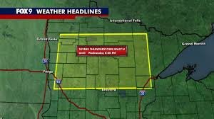
If you are located in Minnesota, Wisconsin, or Iowa, it is crucial to stay vigilant and keep a close eye on local weather updates to ensure your safety and the safety of your family.
Which Areas Are Affected?
The severe weather threat is widespread, covering several key regions across three states:
- Minnesota: Central and northern regions (including Brainerd and Hinckley) are under watch, as well as far southeast Minnesota.
- Wisconsin: Most of the state is included in the warning, with only a few far northeastern counties near the Upper Peninsula excluded.
- Iowa: Eastern counties along the borders of Wisconsin and Illinois are currently under alert.
Most of these watches are expected to remain in effect until 8 p.m. Wednesday.
The Primary Threats: Hail, Wind, and Tornadoes
This is not just a typical rain shower. The NWS has highlighted several severe hazards that could cause significant property damage or injury:
- Dangerous Hail: Scattered large hail is expected, with some stones potentially reaching two inches in diameter (roughly the size of a baseball).
- High Wind Gusts: Winds could reach up to 65 miles per hour, capable of knocking down tree limbs and power lines.
- Tornado Risk: While not the primary threat, the atmosphere is unstable enough that one or two tornadoes could develop.
Understanding the Risk Levels
The severity of the expected weather varies by location. The National Weather Service has categorized the risks as follows:
| Risk Level | Affected Regions |
|---|---|
| Level 3 (Enhanced Risk) | Eastern Minnesota, Western Wisconsin, Eastern Iowa, and Northern Illinois. |
| Level 2 (Slight Risk) | Central Minnesota. |
| Level 1 (Marginal Risk) | Western Minnesota. |
How to Stay Safe During a Severe Thunderstorm
When a severe thunderstorm warning is active, immediate action can save lives. Follow these essential safety tips:
- Seek Shelter: Move indoors immediately. Avoid porches, sheds, or vehicles if a sturdy building is available.
- Stay Away from Windows: High winds and flying debris can easily shatter glass.
- Monitor Alerts: Keep a battery-powered weather radio handy or enable emergency alerts on your smartphone.
- Secure Outdoor Items: Bring in patio furniture or trash cans that could become projectiles in 65 mph winds.
Stay tuned to local meteorologists for real-time updates as these storms develop between 11 a.m. and 7 p.m. today. Your awareness is your best defense against the unpredictability of severe weather.


