
Understanding the North Atlantic Cold Blob Pattern: A Warning Sign for Winter 2026/2027
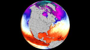
Climate scientists are closely monitoring a chilling phenomenon in the far North Atlantic. A significant cold ocean anomaly—commonly referred to as the North Atlantic cold blob pattern—is expanding once again. This isn’t just a local cooling event; it is a critical indicator of larger atmospheric shifts that could drastically alter the winter weather across North America and Europe for the 2026/2027 season.
When this cold “blob” appears, it rarely acts alone. Combined with the emergence of a powerful Super El Niño in the tropical Pacific, we are seeing a rare planetary setup that provides early, strong hints about temperature and pressure trends for the coming months.
The Science Behind the Chill: AMOC and the Gulf Stream
To understand why the cold blob matters, we have to look at the AMOC (Atlantic Meridional Overturning Circulation). This massive system of currents, which includes the well-known Gulf Stream, acts as a planetary conveyor belt, transporting warm tropical waters toward the North Atlantic and the Polar Circle.
This heat transport is vital for keeping the East Coast of the United States and Europe temperate during winter. However, recent data suggests that the AMOC system is slowing down. As this circulation weakens, warm water fails to reach the north, leaving behind a signature of cooling—the cold blob—particularly east of Newfoundland.
A “Tri-Headed” Climate Pattern: Atlantic, Pacific, and Atmosphere
The current climate setup is particularly complex because it involves three interacting drivers:
- n
- The North Atlantic Cold Blob: An indicator of AMOC weakening and a precursor to jet stream changes.
- Super El Niño: A massive warming event in the Pacific that pushes global weather patterns into a high-energy state.
- The PNA (Pacific-North American) Pattern: The atmospheric link that translates ocean temperatures into actual weather on the ground.
Historically, a strong cold anomaly in the North Atlantic often coincides with a positive PNA pattern. In simple terms, this creates a high-pressure ridge over Western Canada and the Northwestern US, while forcing a low-pressure trough over the East.
What This Means for Winter 2026/2027: Canada and the USA
Based on long-range models from the ECMWF and NOAA, the forecast for the 2026/2027 winter suggests a stark divide in weather patterns:
1. Western Canada and Northwestern US
Due to the positive PNA influence, these regions are likely to experience warmer-than-normal temperatures and higher pressure, potentially leading to milder winters than usual.
2. Eastern Canada and the Eastern US
The opposite is true for the East. A low-pressure zone is expected to dominate the Midwest and Eastern seaboard. This setup often opens a “cold corridor,” allowing the Polar Vortex to dip south, bringing significantly colder-than-average temperatures and potentially heavy snowfall to Eastern Canada and the Eastern United States.
3. Europe
The influence of the Super El Niño typically creates a warm ridge over central and southern Europe, though the far north may still feel the bite of the Atlantic cooling.
Conclusion: Nature’s Dashboard
Ocean anomalies are like the warning lights on a car’s dashboard; they don’t cause the crash, but they tell you exactly what is happening under the hood. The North Atlantic cold blob pattern, paired with a Super El Niño, is a clear signal that the global weather system is shifting.
While long-range forecasts are always subject to change, the alignment of multiple models (ECMWF, CanSIPS, and CFS) suggests that the 2026/2027 winter will be one of high contrast and significant volatility. Stay tuned for further updates as we move closer to the season.


