
Dallas Weather Alert: Will This Storm Finally Break the 56-Day Dry Spell?
For residents of North Texas, the wait for rain has been grueling. After a relentless 56-day dry stretch, the region is finally seeing a glimmer of hope on the horizon. A new weather system is migrating from Oklahoma, bringing the possibility of much-needed moisture to the Dallas-Fort Worth (DFW) metroplex.
What to Expect: Rain, Thunder, and Potential Risks
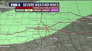
While the promise of rain is welcome, this system comes with a few caveats. Meteorologists are forecasting a 40% chance of isolated showers and thunderstorms. While most of these storms are expected to remain below severe levels, the National Weather Service guidelines suggest keeping an eye on the sky.
The system carries a marginal risk (Level 1 out of 5) for severe weather. The primary threats to watch out for include:
- n
- Damaging Winds: Gusts could exceed 50 to 60 mph.
- Frequent Lightning: A common companion to these isolated cells.
- Localized Impact: There is a estimated 5% chance of severe wind per county.
The Heat Factor: Humidity and Heat Indices
Despite the incoming clouds, the heat isn’t letting up just yet. Morning temperatures started in the mid-to-upper 70s, but as the day progresses, highs are expected to reach the mid to upper 90s.
The real challenge, however, is the humidity. With dew points lingering in the upper 60s and low 70s, the heat index will likely hover near triple digits. Even in areas where the actual temperature stays below 100°F, it will feel significantly hotter, making hydration and shade essential.
Timeline: When Will the Storms Hit?
If you’re planning your afternoon, here is the expected timeline for the Dallas weather shift:
- Morning: Quiet, sunny skies with high humidity.
- Afternoon: Increasing cloud cover, specifically north and northwest of DFW.
- 6 PM to 8 PM: The peak window for isolated thunderstorm development.
- Overnight/Friday Morning: Activity may linger before shifting eastward, potentially providing the relief the soil desperately needs.
Looking Ahead: The Weekend Outlook
Don’t put away your sunscreen just yet. While Friday may see skies clearing from west to east, the relief will be short-lived. Forecasts indicate that temperatures will return to the century mark (100°F+) by the weekend, accompanied by plenty of sunshine.
Stay tuned to local alerts and ensure your outdoor gear is secured in anticipation of those potential 60 mph winds. For more detailed climate data, you can visit NOAA to track long-term trends in Texas weather.



