
Severe Weather Disrupts the Windy City: What You Need to Know
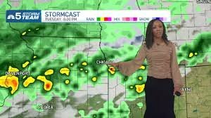
Chicago is currently facing a turbulent weather pattern, with parts of the metropolitan area under a marginal risk for severe weather. This level-one alert indicates that while widespread devastation is unlikely, the potential for impactful storms remains high as we move through the afternoon and evening.
For residents and visitors, the primary concerns are wet commutes and significant travel disruptions. If you are planning to head out, be prepared for “periods of rain” and scattered thunderstorms that could make road conditions treacherous.
Travel Alert: O’Hare International Airport Ground Stop
The most immediate impact of this weather system has been felt in the skies. According to the Federal Aviation Administration (FAA), a ground stop was issued for departures heading to Chicago’s O’Hare International Airport.
Travelers should be aware that these stops are specifically targeting incoming flights to mitigate risks associated with the storms hitting the region. It is highly recommended to check your flight status through your airline’s app or the official airport portal before leaving for the terminal.
Weather Breakdown: Rain, Thunder, and Humidity
The National Weather Service has warned that the highest concentration of rain and embedded thunderstorms is occurring near and north of I-80. While the heaviest activity began in the north and west of the city, the system is expected to shift and evolve.
Key Forecast Details for Tuesday:
- n
- Temperatures: Expect highs in the low-80s.
- Humidity: Dew points are climbing into the 70s, creating a very “muggy” and oppressive feel outdoors.
- Risk Areas: Marginal risks persist mainly south and west of Chicago into the evening.
Safety Tips for Stormy Weather
Safety should be your top priority during these unsettled weather patterns. To stay protected, follow these essential guidelines:
- n
- Seek Shelter: If you hear thunder, immediately move indoors or into a hard-topped metal vehicle.
- Drive with Caution: Heavy rain reduces visibility and increases braking distance. Slow down and maintain a safe distance from other vehicles.
- Stay Informed: Keep an eye on local weather radars and emergency alerts.
Looking Ahead: Will Wednesday Be Better?
Unfortunately, the weather remains unstable. While the intensity of the storms may diminish by Wednesday morning, forecast models suggest that scattered showers will likely persist. The overall pattern for the week remains “unsettled,” meaning the chance for rain could return later in the day on Wednesday.
Stay tuned for further updates as the Storm Prediction Center continues to monitor the weakening afternoon system and its potential for reorganization.



