
National Hurricane Center Tracks Invest 91L: Could Tropical Storm Bertha Form?
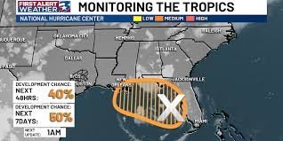
Residents along the Gulf Coast are keeping a close eye on the horizon as a new weather disturbance stirs in the eastern Gulf of Mexico. Identified as Invest 91L by the National Hurricane Center (NHC), this system is currently under tight surveillance to determine if it will evolve into a named storm.
Current Development Probability
The latest meteorological data suggests that the system has a significant chance of intensifying. According to the NHC, the probabilities of development are as follows:
- n
- Next 48 Hours: 40% chance of development.
- Next 7 Days: 50% chance of development.
The Science Behind the Storm
What is driving this disturbance? Forecasters point to a combination of an upper-level low situated over Florida and a weak surface trough. Together, these atmospheric conditions are acting as a catalyst, sparking powerful thunderstorms over the warm Gulf waters.
These storms are already producing noticeable effects, including:
- Frequent lightning strikes.
- Gusty surface winds.
- Locally rough sea conditions.
When Does It Become “Bertha”?
At this moment, maximum sustained winds are estimated at approximately 23 mph. However, the threshold for a tropical storm is much higher. If Invest 91L strengthens to maximum sustained winds of 39 mph, it will officially be classified as a tropical storm and will receive the next name on the Atlantic list: Bertha.
Potential Impacts for Coastal Communities
While the system’s path remains uncertain, the primary concern for now is the delivery of heavy rain and severe storms. The areas most likely to feel the impact range from the Florida coast to the Louisiana Gulf coast. Residents and travelers in these regions should remain vigilant, as these weather patterns could disrupt travel plans and beach activities in the coming days.
Local Outlook: Brazos Valley, Texas
In contrast to the volatility in the Gulf, the Brazos Valley is expected to experience a different trend. Under the influence of high pressure, the region will likely remain hot and mostly dry. This marks a return to typical summer patterns as Texas continues to dry out following a recent period of excessive rainfall.
Stay tuned for further updates from the National Hurricane Center to ensure you are prepared for any sudden changes in weather patterns.



