
Severe Storm Forecasts: A Rare ‘Autumn-Style’ System is Sweeping Through Ontario and Quebec
Residents across Ontario and Quebec should prepare for a significant weather disruption this week. In a turn of events that feels more like October than June, a powerful and unusually deep low-pressure system is moving across North America, bringing with it the threat of heavy rainfall, high winds, and volatile atmospheric conditions.
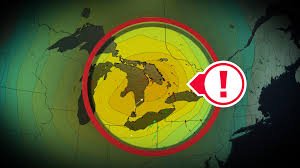
A Record-Breaking Low-Pressure System
The system originated in the United States Midwest, specifically impacting the Chicago area with intense rain and severe storms. As it tracks northeast, it is expected to bring an extraordinary level of intensity to Canada. Meteorologists are keeping a close eye on the central pressure of the system, which could drop to 990 hPa or lower.
This specific pressure reading is highly unusual for early summer. In fact, it could potentially set a new monthly record for June in Windsor, Ontario. The strength and organization of this system are far more characteristic of a well-developed autumn storm than a typical early-summer weather pattern.
What to Expect: Ontario and Quebec Impact
While Ontario will be the first to feel the brunt of the system, the effects will be felt deeply across Quebec as the depression moves eastward. This system isn’t just about a single number on a barometer; it’s about the concrete impacts on the ground.
Key Weather Alerts for Thursday:
- Heavy Precipitation: Large corridors of rain are expected, with some areas in Quebec potentially receiving up to 50 mm of rain by Thursday evening.
- Powerful Wind Gusts: Wind speeds could become erratic and dangerous, with gusts exceeding 70 km/h anticipated late Thursday.
- Severe Thunderstorms: Due to atmospheric instability, there is a high potential for the development of severe storm cells, particularly as the system crosses from Ontario into Quebec.
For real-time updates and official warnings, it is highly recommended to monitor Environment Canada, the leading authority for national weather alerts.
Beyond the Storm: A Cooler Outlook
The arrival of this system isn’t just about the immediate danger of wind and rain. Following the passage of the depression, the “backside” of the storm is expected to pull in significantly cooler air.
Instead of sliding into a typical summer heatwave, the end of June is likely to remain cooler than average. This further reinforces the “autumnal signature” of this weather event—from the intensity of the severe storm forecasts to the crisp air that follows.
Final Safety Tips
Given the forecast, this is a week where a sturdy umbrella is a necessity—provided you can keep it from blowing away in the 70 km/h winds. We advise residents to:
- Secure outdoor furniture and loose objects.
- Plan commutes around the peak intensity on Thursday.
- Stay tuned to local weather reports for immediate flash flood or wind warnings.
This report was developed with meteorological insights to keep Canadians safe and informed during volatile weather transitions.


