
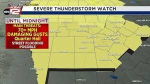
Weather Forecast Texas: Severe Thunderstorm Alerts for South Central Texas
Texas weather is known for its unpredictability, and right now, residents in South Central Texas need to stay vigilant. A Severe Thunderstorm Watch has been issued, bringing potential danger to several key regions. If you are in the path of these storms, staying informed is your best defense.
Immediate Alerts: Austin and San Antonio Under Threat
The Storm Prediction Center (SPC) has highlighted significant risks for tonight. The severity varies by location, but the potential for impact is high:
- n
- Hill Country & Austin Metro Area: Currently under a Level 3 risk (out of 5), indicating a higher probability of severe weather.
- San Antonio Metro Area: Currently under a Level 2 risk for severe storms.
What to Expect: Winds, Hail, and Flooding
These storms aren’t just typical rain showers. Meteorologists are warning of several primary threats that could cause property damage or safety hazards:
- n
- Damaging Winds: The most significant threat is straight-line wind gusts that could reach 70 mph or greater.
- Hail: Expect quarter-sized hail in some areas.
- Flash Flooding: Locally heavy rainfall may lead to brief but intense street flooding.
Stay Safe: Essential Precautions
Because these storms can move quickly and potentially knock out power, it is crucial to prepare now. Here are a few quick tips to keep you and your family safe:
- n
- Charge Your Devices: Ensure your smartphones and tablets are fully charged.
- Set Up Alerts: Have a reliable way to receive weather warnings (such as a NOAA weather radio or mobile app) in case the electricity goes out.
- Secure Outdoor Items: With 70 mph winds possible, move patio furniture and trash cans indoors.
Looking Ahead: The Extended Weather Forecast for Texas
The good news? The volatility won’t last forever. Once the cold front passes through, we can expect a much more pleasant atmosphere.
Monday’s Outlook: Temperatures will see a slight dip, with highs ranging from the upper 70s to low 80s, providing a refreshing break from the heat.
Mid-to-Late Week: As we move further into the week, a gradual warming trend will return. Expect plenty of sunshine and dry conditions, with temperatures climbing back into the 90s by late week.
Stay tuned to your local weather authority for real-time updates and keep safety as your top priority during these severe weather events.



