
Tornado Warning Wisconsin: Live Updates on Severe Storms and Flash Flooding
Southeastern Wisconsin is bracing for a night of severe weather, with a significant threat of damaging winds, large hail, flooding, and even tornadoes. Storms are forecast to impact the region between 5 and 11 p.m. Friday, potentially lingering into early Saturday morning. The combination of atmospheric instability and moisture could lead to rapidly developing and dangerous conditions.
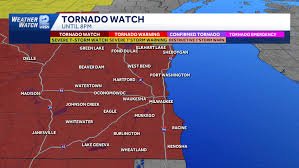
Current Warnings & Updates (as of April 17th)
- 8:13 p.m.: Severe Thunderstorm Warning issued for Milwaukee and Waukesha counties until 9 p.m.
- 7:57 p.m.: Tornado Warning issued for Milwaukee County until 8:45 p.m. Waukesha County extended until 8:45 p.m.
- 7:47 p.m.: Tornado Warning extended until 8:45 p.m. for Walworth, Kenosha, and Racine counties.
- 7:44 p.m.: Flash Flood Warning issued for Milwaukee, Jefferson, Racine, Walworth, and Waukesha counties until 10:45 p.m.
- 7:35 p.m.: Tornado warning for Racine and Waukesha counties extended until 8 p.m.
- 7:26 p.m.: Severe thunderstorm warning issued for Milwaukee, Ozaukee, Washington, and Waukesha until 8:15 p.m.
- 7:12 p.m.: Tornado warnings issued for Racine, Kenosha, and Walworth counties until 8 p.m.
- 7:09 p.m.: Tornado Warning issued for Waukesha County until 7:45 p.m.
- 7:06 p.m.: Severe Thunderstorm Warning issued for Milwaukee, Kenosha, Racine, Walworth, and Waukesha counties.
- 7:03 p.m.: Flash Flood Warning issued for Jefferson and Dodge counties until 10:15 p.m.
- 6:46 p.m.: Tornado Warning issued for Dodge and Jefferson counties until 7:30 p.m.
Flood Risk is High
The primary concern alongside tornadoes is flooding. Southeastern Wisconsin has already received nearly seven inches of rainfall in the past week – almost double the typical monthly amount. With an additional 1-3 inches of rain expected tonight, the already saturated ground cannot absorb much more water. This creates a high risk of flash flooding, especially near rivers, streams, and creeks.
Affected Areas
Communities in the path of the storms include Sheboygan, Grafton, Milwaukee, Oak Creek, Caledonia, Racine, and Burlington. Residents in these areas should be particularly vigilant and prepared for rapidly changing conditions.
Safety Precautions
- Stay Informed: Monitor local news, weather apps (like the WISN 12 News app), and the National Weather Service for the latest updates.
- Have a Plan: Know where to shelter in case of a tornado or flash flood.
- Charge Devices: Ensure your phones and mobile devices are fully charged in case of power outages.
- Weather Radio: Have a weather alert radio available indoors, as outdoor sirens may not be audible inside.
- Avoid Travel: If possible, avoid unnecessary travel during the severe weather.
School & Activity Cancellations
Several school districts have canceled Friday evening activities, including:
- Wauwatosa School District and Recreation Department
- Elkhorn School District
- Menomonee Falls School District
Milwaukee Public Schools (MPS) has canceled after-school recreation, athletics, and events, but after-school camps and Safe Places will remain open, though early pickup is encouraged.
Looking Ahead
A strong cold front will move through the area after the storms, bringing cooler temperatures over the weekend. Dry conditions are expected to return next week. For more information on severe weather preparedness, visit the National Weather Service website.


