
Houston Weather Alert: Fire Watch Declared, Temperatures Plummet After Cold Front
Houston and Southeast Texas are bracing for a dramatic shift in weather patterns this week, marked by critical fire conditions and a significant plunge in temperatures. Following a weekend of near-record highs, a powerful cold front is ushering in dry, gusty winds and unseasonably cold air, demanding immediate attention for outdoor safety.
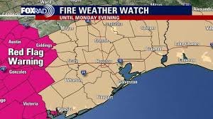
Critical Fire Danger Looms Over Southeast Texas
A Fire Weather Watch has been issued for all of Southeast Texas, effective from Sunday morning through Monday evening. This critical alert is primarily due to the arrival of a cold front overnight Saturday, bringing with it strong, gusty northerly winds that could reach up to 30 mph, combined with significantly drier air. These conditions create a volatile environment where any outdoor fire could spread rapidly and aggressively across the region.
Authorities are strongly advising against any outdoor burning. The region is currently experiencing worsening drought conditions, amplifying the risk. Many burn bans remain in place across Texas, including numerous localities within the greater Houston area. Ignoring these warnings could lead to devastating consequences, so residents must exercise extreme caution to prevent accidental sparks.
Dramatic Temperature Plunge & Chilly Outlook for Houston
The same cold front responsible for the elevated fire risk will also deliver a sharp drop in temperatures, a welcome change for some, but one that requires preparation. After highs in the low 70s on Sunday, overnight lows Sunday into Monday will dip into the low 40s. Areas north of Houston could even see temperatures plummet into the mid-upper 30s on both Monday and Tuesday mornings.
Wind chills, or “feels-like” temperatures, are expected to be particularly biting, likely ranging from the 20s to low 30s on Monday morning. This significant drop marks the coldest weather Houston has experienced since February, making proper layering essential, especially for children waiting at bus stops. Bundle up!
The possibility of ground frost is also a concern for these chilly mornings, particularly outside urban areas. While this cold snap will be brief, it’s a stark reminder of winter’s potential. Looking ahead, the temperature swings continue, with forecasts indicating a return to the 80s by mid to late next week.
Tropical Activity Winding Down for the Gulf
On a different note, residents can breathe a sigh of relief regarding tropical weather. The Atlantic Basin is not expected to see any tropical cyclone activity over the next seven days. With hurricane season officially ending on November 30th, the chances for any significant tropical development in the Gulf of Mexico for the remainder of this month are extremely low. Activity is definitively winding down as the season draws to a close.
Stay Informed and Stay Safe, Houston!
The ever-changing Houston weather demands vigilance. From critical fire warnings to dramatically falling temperatures and potential frost, staying informed is key. Monitor official weather sources like the National Weather Service Houston/Galveston for the latest updates and adhere to all safety recommendations. Your safety, and that of our community, depends on it.


