
Red Flag Warning: Brace for the Season’s First Major Freeze in the Carolinas
The Carolinas are on the cusp of a dramatic shift. After days of unseasonably mild November weather, a significant pattern change is imminent, bringing with it the coldest air of the season so far. While Friday offers a serene start, consider it the calm before a winter-like weather ‘red flag warning’ for what’s to come.
A Brief Interlude of Mildness
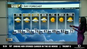
Friday promises a comfortable day, bathed in a mix of sun and clouds, largely staying dry. As evening approaches, watch the skies gradually gray as clouds gather, signaling the arrival of an approaching front. Overnight into early Saturday, a weak cold front will gently slide through, bringing some light rain showers primarily to our mountain communities. Foothill residents might experience light to moderate rain during early Saturday, with occasional breaks of sunshine. For those in the Charlotte metro area, the impact will be minimal – perhaps a few sprinkles or brief drizzles, but widespread rain is not expected. Temperatures will remain above average, with afternoon highs touching the low to mid-70s. Despite the front, no significant cooldown is expected just yet, making Friday and much of Saturday still perfect for fall activities.
The Impending Arctic Blast: A True Red Flag Warning
Get ready for a profound flip in the weather switch. A major pattern change is about to unfold, ushering in the coldest air of the season. As the next strong cold front barrels in, there’s a low risk of a few strong storms on Saturday evening. Most areas, especially south of I-85 between mid and late evening, should expect scattered showers and a general chance of thunderstorms. While widespread severe weather isn’t anticipated, don’t be surprised by a rumble of thunder or a brief, intense downpour before midnight. Rain might linger into early Sunday morning before tapering off.
By Sunday, the true impact of this ‘red flag warning’ will be felt. The front will sweep eastward across the Carolinas, leaving behind a torrent of much colder, drier air funneled in by strong northwesterly winds. The mountains will be the first to feel this sharp decline, with gusts potentially exceeding 35 mph throughout the afternoon. Temperatures will plummet steadily throughout the day, unmistakably signaling the official arrival of our fall chill. For detailed wind advisories, always check your local National Weather Service warnings.
Preparing for the First Freeze and Mountain Snow
Once the colder air fully establishes itself, mountain flurries could develop from Sunday night into early Monday. While significant accumulation isn’t expected, it will serve as a stark reminder that winter is not far away – a wintry preview even before Thanksgiving season arrives!
Monday will deliver a shock to the system. Highs will struggle to reach the 40s, marking what will likely be our coldest day since late February. Add a steady breeze, and the ‘feels like’ temperature will be even chillier. As Monday night deepens, so does the cold. Temperatures across the region will drop well below freezing, with lows plunging into the 20s for the first time since early March in Charlotte and surrounding areas. This is a critical ‘red flag warning’ for vulnerable outdoor elements:
- Sensitive Plants: Cover or bring indoors.
- Outdoor Pipes: Protect exposed pipes to prevent bursting. Learn more about preventing frozen pipes.
- Pets: Ensure pets have warm shelter.
The mountains will continue to experience off-and-on snow showers from Sunday night through Tuesday. Some light accumulation is possible in the higher elevations, painting a picturesque, albeit cold, early winter scene.
Stay Prepared, Stay Warm
This major shift in weather patterns is a definitive ‘red flag warning’ for everyone to prepare for significantly colder temperatures. Dig out those winter coats, check your heating systems, and take precautions to protect your home and garden. Stay warm and stay safe as the Carolinas welcome their first true taste of winter!


