
What is a Tornado Watch? A Comprehensive Guide
Alabama residents are bracing for a potent cold front tonight, bringing with it the potential for damaging winds and, in some areas, isolated tornadoes. Understanding the difference between a tornado watch and a tornado warning is crucial for staying safe. This article will break down what a tornado watch means, how to prepare, and what to do if conditions escalate.
What Does a Tornado Watch Mean?
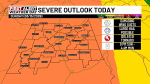
A tornado watch is issued by the Storm Prediction Center (SPC) when atmospheric conditions are favorable for the development of tornadoes in a specific area. It doesn’t mean a tornado is currently happening, but rather that one *could* form. Think of it as a heads-up – a signal to be prepared. As of 9:43 p.m. tonight, several Alabama counties are under a Tornado Watch until 4 a.m. (check NOAA’s Storm Prediction Center for the latest updates).
Key Differences: Watch vs. Warning
It’s vital to understand the distinction:
- Tornado Watch: Conditions are favorable for tornadoes to develop. Be prepared!
- Tornado Warning: A tornado has been sighted or indicated by weather radar. Take shelter immediately!
Preparing for a Tornado Watch
When a tornado watch is issued, take these steps:
- Stay Informed: Monitor local news, weather apps (like the WBRC First Alert Weather App), and NOAA Weather Radio for updates.
- Have a Plan: Discuss a safety plan with your family, including a designated safe room or shelter.
- Secure Outdoor Objects: Bring inside anything that could be blown around by strong winds.
- Charge Devices: Ensure your cell phones and other devices are fully charged.
- Be Aware of Gradient Winds: Outside of thunderstorms, winds may gust over 40 mph, potentially causing power outages.
What to Expect After the Front Passes
This weather system is fast-moving, but it will bring significant changes. Following the severe weather threat, temperatures will plummet. We’re transitioning from the 70s today to the 30s by Monday morning. While major snow accumulation isn’t expected due to warm ground temperatures, flurries or light snow showers are possible, especially in higher elevations. A Wind Advisory is in effect for Monday, with wind chills dropping into the 20s.
Freeze Alert for Tuesday & Wednesday
Clear skies on Tuesday will lead to freezing temperatures, potentially impacting sensitive vegetation. Lows are expected to dip into the 20s, with wind chills possibly falling into the teens. Another light freeze/frost is anticipated Wednesday morning. Temperatures will gradually rebound through the weekend, offering a drier stretch of weather.
Where to Find Live Coverage
Stay updated with live coverage on:
- WBRC First Alert Weather App
- WBRC Streaming App
- WBRC Website Livestream
- WBRC YouTube Channel
- iHeart stations statewide and WOXI/WJXI in Calhoun County
Download the WBRC First Alert Weather app for Android and Apple devices. Get news alerts in the Apple App Store and Google Play Store or subscribe to our email newsletter here.
Stay safe and be prepared!
Copyright 2026 WBRC. All rights reserved.


