
WMUR Weather Update: Historic Blizzard Set to Slam Southern New England
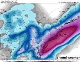
A powerful nor’easter is currently unleashing blizzard conditions across Southern New England, and the worst is yet to come. This storm, tracked closely by WMUR weather experts, is expected to dump over two feet of snow in some areas, accompanied by dangerously strong, gusty winds. Travel is expected to become nearly impossible, particularly during the first half of Monday, as snowfall rates reach 1 to 3 inches per hour, combined with fierce winds.
Blizzard Warning & Expected Impacts
A Blizzard Warning is in effect from 4 p.m. Sunday to 7 a.m. Tuesday for most of Southern New England, extending into coastal New Hampshire and Maine. Residents are strongly advised to prepare for widespread school closures and a significant increase in remote work arrangements on Monday. The National Weather Service (https://www.weather.gov/) is urging extreme caution.
Wind Gusts & Coastal Concerns
Winds will intensify throughout Monday afternoon, with gusts reaching 50 to 70 mph along the coastline. Cape Cod is particularly vulnerable, with the potential for hurricane-force winds of up to 75 mph. These powerful winds pose a significant threat of power outages and coastal flooding. The National Hurricane Center provides valuable information on coastal storm impacts.
Storm Timeline: Hour-by-Hour Breakdown
Here’s a detailed timeline of the storm’s progression through Tuesday morning:
- 3 a.m. to Sunrise: Expect 5 to 10 inches of snow accumulation from Boston to the southern coast, with 3 to 6 inches north of the Massachusetts Turnpike (Mass Pike).
- Sunrise to Early Afternoon: Blizzard conditions are highly likely along the coastline, making outdoor activity extremely dangerous. Snowfall will be intense, with potential for heavy banding – meaning some areas will experience significantly higher snowfall rates than others.
- Afternoon (1 p.m. – 8 p.m.): Snowfall amounts will vary considerably. Some areas could receive an additional 4 to 5 inches, while others may only see 1 to 2 inches. Areas east of Route 128 are most likely to experience the higher snowfall totals.
- Monday Night: Skies will begin to clear, and the snow will taper off. Final snowflakes are expected to fall between 6 and 9 p.m., with winds gradually diminishing.
Safety Precautions & Resources
Stay safe during this severe weather event by following these precautions:
- Avoid unnecessary travel.
- Charge electronic devices.
- Ensure you have an adequate supply of food, water, and medications.
- Check on elderly neighbors and family members.
For the latest updates and safety information, visit the WMUR Weather website: https://www.wmur.com/weather
Ken Mahan can be reached at ken.mahan@globe.com. Follow him on Instagram @kenmahantheweatherman.


