
Hurricane Nolo: Hawaii Braces as Storm Intensifies into a Major Category 3 Hurricane
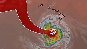
The islands of Hawaii are currently on high alert as Hurricane Nolo continues its westward trajectory. After remaining stationary for several hours, the storm is now gaining momentum and is projected to strengthen into a powerful Category 3 major hurricane by Sunday as it moves south of the island chain.
While the eye of the storm is moving away from the Big Island at approximately 9 mph, the remnants and outer bands continue to lash the region with dangerous conditions, making this one of the most significant weather events the area has seen in decades.
Current Weather Warnings and Impacts
Although general hurricane watches have been discontinued, the danger is far from over. Local authorities have replaced them with high wind warnings for portions of the Big Island and Maui County. Here is what residents and travelers need to know:
- n
- Dangerous Winds: Gusts of up to 75 mph are possible, with the highest risks found at the tops of mountain slopes and downwind areas across the entire island chain.
- Torrential Rainfall: Some areas of the Big Island have already reported rainfall totals exceeding 12 inches.
- Flooding and Mudslides: Flood watches remain active for the Big Island, Maui, Lanai, Molokai, and Kahoolawe. Steep terrain is particularly vulnerable to debris flows and mudslides.
Coastal Hazards: High Surf and Rip Currents
Beyond the wind and rain, Hurricane Nolo is generating massive swells that are creating perilous conditions along the coastline. The National Hurricane Center (NHC) warns of dangerous surf and strong rip currents, specifically impacting the Big Island through the weekend. Coastal flooding remains a significant threat to low-lying areas.
A Historic Weather Event: The 67-Year Mark
The intensity of Hurricane Nolo is not just concerning—it’s historic. According to the NOAA hurricane database, only one other major hurricane (Category 3 or stronger) has tracked within 150 miles of the Big Island in the last several decades: Hurricane Dot in August 1959.
This makes Nolo the strongest hurricane impact to hit the Big Island in 67 years, underscoring the severity of the current weather pattern.
A Season of Unrest: From Lala to Lowell
Hurricane Nolo is the fourth system to significantly affect Hawaii this season, contributing to a saturated landscape that increases the risk of disaster. The sequence of storms includes:
- Hurricane Lala: Hit the Big Island in mid-August with torrential rain and massive power outages.
- Tropical Storm Moke: Brought additional rain to already saturated soils, causing secondary flooding.
- Hurricane Lowell: A beast that reached Category 5 strength at its peak, slamming the western islands with extreme wind and waves.
- Hurricane Nolo: The current threat, intensifying into a major hurricane.
Residents are urged to remain vigilant, monitor local weather updates, and follow all evacuation orders to ensure safety during this volatile hurricanes weather period.



