
Atlantic Hurricane Season 2026: An Unusual Calm and the Influence of Super El Niño
The 2026 Atlantic hurricane season is unfolding in a way that few meteorologists could have predicted. While we typically brace for intense storms this time of year, the Atlantic has remained remarkably quiet, leaving many to wonder if this year will break historical norms.
Quiet Waters in the Atlantic
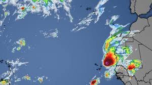
According to the latest monitoring and data from the National Hurricane Center, the Atlantic basin is currently devoid of any major threats. Two systems that were under close surveillance recently, Fay and Gonzalo, have continued to weaken over the past 24 hours.
Fortunately, both systems are located far east in the open Atlantic, posing zero threat to the Caribbean or the lower 48 United States. This lack of activity has led to a striking milestone: the record for the latest first hurricane of the season has already been broken, and the gap continues to widen.
Looking ahead, the next system to form will be named Hanna. However, current outlooks and the EURO-based futurecast show no notable tropical activity brewing in the Atlantic, Caribbean, or the Gulf of Mexico for the coming days.
Turbulence in the Eastern Pacific
While the Atlantic enjoys a period of dormancy, the opposite is happening on the other side of the globe. The Eastern Pacific is experiencing extreme activity, with two major hurricanes currently positioned off the coast of Baja California.
- n
- Storm Polo: This notable system is forecast to weaken gradually, though it may still maintain Category 1 or Category 2 status before making landfall north of Cabo San Lucas.
- Pacific Trends: The region remains volatile, contrasting sharply with the stillness of the Atlantic.
The Science: How Super El Niño is Shaping the Season
The primary driver behind this atmospheric disparity is the Super El Niño. This phenomenon involves the significant warming of the Eastern Pacific waters, which creates a ripple effect across global weather patterns.
As detailed by NOAA, a strong El Niño typically increases vertical wind shear in the Atlantic. This shear effectively “rips apart” developing storms before they can organize into hurricanes, while simultaneously fueling more intense activity in the Pacific.
Will 2026 Be a Hurricane-Free Year?
It may seem unbelievable, but it is entirely possible that the Atlantic will not see a single hurricane before the season officially ends on November 30th. While such an occurrence would be extremely rare in meteorological history, the ongoing Super El Niño conditions make it a realistic possibility.
Whether we see a late-season surprise or a record-breaking calm, staying informed through official channels is the best way to ensure safety and preparedness.



