
Tropical Storm Weather Forecast: Hurricane Polo and Pacific Systems on High Alert
The global weather landscape is currently witnessing a dramatic contrast between the Atlantic and Pacific basins. While one side remains unusually quiet, the other is fueling powerful systems that demand immediate attention. If you are looking for the most accurate tropical storm weather forecast, staying informed about these evolving systems is crucial for safety and preparation.
The Pacific Powerhouse: Hurricane Polo and Tropical Depression 15-E
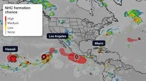
The Central and Eastern Pacific are currently the most active regions, with two major systems causing concern for residents in Mexico and Hawaii.
Hurricane Polo: A Category 5 Threat
The most critical system currently under watch is Hurricane Polo. After a period of rapid intensification, Polo surged to a devastating Category 5 strength. Although it is projected to remain a relatively small hurricane, its trajectory is unsettlingly close to the southwestern coast of Mexico.
- n
- High-Risk Areas: Southwestern Mexico Pacific coast and the southern Baja Peninsula.
- Warning: Residents in these regions should closely monitor the National Hurricane Center (NHC) for real-time updates, as subtle shifts in the storm’s track can significantly alter the impact zone.
Tropical Depression 15-E: Concerns for Hawaii
Meanwhile, Tropical Depression 15-E has reemerged in the Pacific and is charting a course toward Hawaii. The primary concern here is not wind, but water. Parts of Hawaii are already “flood-fatigued,” and the arrival of 15-E could bring heavy, soaking rains, further increasing the risk of locally flooding, particularly on the Big Island.
Atlantic Outlook: A Rare Quiet Period
In stark contrast to the Pacific, the Atlantic Basin has been historically quiet this season. However, meteorologists are keeping an eye on a new tropical wave moving off the coast of western Africa.
While this system may bring rain to the Cabo Verde Islands, current models suggest it poses no immediate threat to other landmasses in the Atlantic. This disparity in activity is often measured by Accumulated Cyclone Energy (ACE), a metric that accounts for both the intensity and duration of storms. This season, the ACE values show a dormant Atlantic and a hyper-active Eastern Pacific.
The Science Behind the Storms: What Stops a Hurricane?
Why do some systems explode into Category 5 hurricanes while others vanish? Two primary “nemeses” often hinder tropical development:
- Wind Shear: This is the difference in wind speed and direction at different altitudes. High wind shear acts as a disruptive force, effectively “ripping apart” the structure of developing tropical cyclones.
- Dry, Dusty Air: Every year, plumes of dust-laden air from the Sahara Desert stream across the Atlantic. This sinking, dry air suppresses the thunderstorm development that serves as the building block for tropical storms.
For more detailed information on how ocean temperatures affect these patterns, you can explore the research provided by NOAA (National Oceanic and Atmospheric Administration).
Stay Prepared and Informed
Weather patterns can shift in an instant. Whether you are in the path of Hurricane Polo or monitoring the rainfall in Hawaii, the best defense is a good tropical storm weather forecast and a ready-to-go emergency plan. Keep your devices charged, stay tuned to local authorities, and prioritize safety above all else.



