
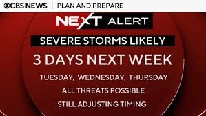
Philadelphia Weather Alert: Unsettled Week Ahead with Heat and Severe Storms
If you are living in or visiting the City of Brotherly Love, it is time to keep a close eye on the skies. The transition from August to September is bringing a volatile weather pattern to the Philadelphia region, characterized by oppressive humidity, soaring temperatures, and a significant risk of severe thunderstorms.
The Start of September: A Dangerous Mix of Heat and Humidity
While Monday begins with a relatively mild transition—featuring scattered showers and cloudy skies—the atmosphere shifts dramatically as we enter September. From Tuesday through Thursday, Philadelphia will face a grueling stretch of summer heat.
Meteorologists are warning that temperatures will hover around 90°F, but the high humidity will push the “feels-like” temperature into the 95°F to 100°F+ range. This level of heat can be dangerous, making it crucial to stay hydrated and limit outdoor activities during peak sun hours.
Severe Storm Risks and Supercells
The most concerning aspect of this week’s weather in Philadelphia is the atmospheric instability. A ridge of high pressure will act as a catalyst for clusters of storms, including the potential for individual supercell storms. These types of storms are known for their intensity and can bring various threats, including heavy rainfall and strong winds.
According to the Storm Prediction Center (SPC), the region remains under a risk alert for three consecutive days. The peak of this instability is expected on Thursday, as a strong cold front pushes through the area, potentially triggering the most severe weather events of the week.
Weekly Weather Breakdown
To help you plan your week, here is the detailed forecast for the Philadelphia region:
- n
- Monday: Scattered showers. High 84°F | Low 72°F.
- Tuesday: ⚠️ Severe Weather Alert. Intense heat and storms. High 90°F | Low 74°F.
- Wednesday: ⚠️ Severe Weather Alert. High humidity and storm clusters. High 90°F | Low 73°F.
- Thursday: ⚠️ Peak Severe Threat. Strong cold front arrival. High 91°F | Low 73°F.
- Friday: Conditions stabilize. Partly cloudy with a stray shower. High 85°F | Low 73°F.
- Saturday: Pleasant and partly cloudy. High 80°F | Low 68°F.
- Sunday: Calm and partly cloudy. High 80°F | Low 64°F.
How to Prepare and Stay Safe
With the threat of both extreme heat and severe lightning, preparation is key. We recommend the following safety measures:
- n
- Hydration: Drink plenty of water throughout the day, especially on Tuesday and Wednesday.
- Pet Safety: Ensure your pets have access to cool shelter and fresh water.
- Stay Informed: Monitor real-time updates via the National Weather Service or your preferred local weather app.
- Emergency Plan: Identify a safe indoor location in case supercell storms develop in your immediate area.
As the cold front passes on Thursday, Philadelphia can look forward to a much more comfortable weekend with temperatures dipping back into the low 80s. Stay weather-aware and stay safe!



