
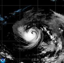
The Power of the Pacific: Hurricane Karina’s Rapid Intensification
The Pacific Ocean is currently witnessing a display of nature’s raw power. Hurricane Karina has rapidly intensified, officially escalating into a formidable Category 4 storm. Fueled by exceptionally warm open waters, the storm has seen a dramatic surge in strength since it first became a hurricane on Sunday.
According to the latest data from the National Hurricane Center (NHC) in Miami, Karina is currently packing maximum sustained winds of 233 km/h (145 mph). While its power is intimidating, there is a silver lining for coastal residents.
Current Position and Potential Impacts
As of the most recent reports, Hurricane Karina is located approximately 1,642 kilometers (1,020 miles) west-southwest of the southern tip of Mexico’s Baja California peninsula. The storm is maintaining a steady westward trajectory, meaning it currently poses no direct threat to land.
However, meteorologists warn that while the center of the storm is far offshore, the periphery of the system could still cause disruptions:
- n
- Coastal Swells: Both Mexico and Southern California may experience increased surf and dangerous rip currents.
- Intensity Fluctuations: Experts predict further strengthening followed by periods of intensity fluctuation as the storm continues its path.
Tropical Storm Lowell: A Growing Concern for Hawaii
While all eyes are on Karina, another system is gaining momentum in the Pacific. Tropical Storm Lowell is currently positioned about 1,376 kilometers (855 miles) east-southeast of Hilo, Hawaii.
With sustained winds of 97 km/h (60 mph) and moving westward, meteorologists are closely monitoring Lowell’s evolution. There is a high probability that Lowell will strengthen into a full-fledged hurricane by Monday night or Tuesday.
What this means for Hawaii
Although there is no immediate threat to the islands, the storm’s projected path suggests it could be in the vicinity of the Hawaiian Islands later this week. Residents and travelers are encouraged to stay vigilant and monitor official weather channels.
For real-time satellite imagery and official warnings, you can visit the National Oceanic and Atmospheric Administration (NOAA) website to stay informed about these evolving weather patterns.



