Tropical Cyclone Horacio: A Powerful Start to the 2026 Season
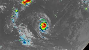
On Monday, February 23, 2026, the world witnessed the birth of its first Category 5 tropical cyclone: Tropical Cyclone Horacio. This powerful storm rapidly intensified over the warm waters of the remote South Indian Ocean, reaching peak sustained winds of 160 mph (260 km/h). This makes Horacio a significant meteorological event, and a stark reminder of the increasing intensity of tropical cyclones in a warming world.
Favorable Conditions Fuelled Horacio’s Strength
Horacio’s rapid intensification wasn’t a surprise, given the exceptionally favorable conditions it encountered. Sea surface temperatures of 27-28 degrees Celsius (81-82°F) provided ample energy, while moderate wind shear allowed the storm to organize and strengthen without being torn apart. These conditions created a perfect breeding ground for a rapidly intensifying cyclone.
Current Status and Forecast
According to the Joint Typhoon Warning Center, Horacio has likely reached its peak intensity. The forecast indicates a steady weakening trend as the cyclone moves southward over cooler waters and into an area with increased wind shear. Fortunately, Horacio is currently far from any landmasses, posing a threat only to marine interests. Precise tracking and forecasting are crucial, and updates can be found at the National Hurricane Center.
A Rare Southern Hemisphere Event
Horacio marks the first Category 5 cyclone in the Southern Hemisphere since Cyclone Errol achieved that status off the coast of northwestern Australia on April 16, 2025. This highlights the potential for increasingly intense storms in this region.
The Increasing Frequency of Category 5 Storms
Historically, the average yearly number of Category 5 storms globally between 1990 and 2025 was 5.3. However, 2025 saw a total of five Category 5 storms: Hurricanes Melissa, Erin, and Humberto in the Atlantic; Typhoon Ragasa in the Northwest Pacific; and Cyclone Errol in the South Indian Ocean. This trend, coupled with Horacio’s early appearance in 2026, raises concerns about the future frequency and intensity of these devastating storms.
Climate Change and Tropical Cyclone Intensification
The scientific consensus is clear: climate change is expected to increase the proportion of tropical cyclones that reach Category 4 and 5 strength. Warmer ocean temperatures provide more energy for these storms, allowing them to intensify more rapidly and reach higher peak intensities. Understanding this connection is vital for preparing for and mitigating the impacts of future storms. You can learn more about the link between climate change and extreme weather events at NASA’s Climate Change website.
Republishing Information
This article is available for free republication under a Creative Commons Attribution-NonCommercial-NoDerivatives 4.0 International License. Please see Creative Commons for details.
By Jeff Masters, Yale Climate Connections
February 23, 2026