VOCM News: Canada Braces for Nationwide Weather System
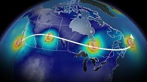
Canadians from British Columbia to the Maritimes are preparing for a significant weather event this week. A powerful low-pressure system is tracking across the country, promising a diverse range of conditions – from heavy alpine snowfall to substantial rainfall and potentially disruptive winds. VOCM News is committed to keeping you updated with the latest information.
British Columbia & The Prairies: Snow and Rainfall Warnings
The system is already impacting British Columbia’s South Coast and Sunshine Coast as of Tuesday. Coastal mountains and the Columbias, at elevations above 1,000 meters, are forecast to receive 40-50 cm of heavy alpine snow. This substantial snowfall raises significant avalanche risks and is likely to cause travel disruptions through mountain passes. Travellers are urged to check DriveBC for the latest road conditions.
The Lower Mainland will experience significant rainfall, with Vancouver anticipating 20-30 mm and the eastern Fraser Valley potentially seeing 50-75 mm, increasing the risk of localized flooding. Wind gusts of 50-70 km/h are expected late Tuesday, potentially leading to power outages.
As the system moves eastward, snow will spread into the Rockies and Edmonton by Tuesday evening. Accumulations of 5-15 cm are likely across the Prairies by Wednesday, with Saskatchewan expected to bear the brunt of the snowfall. Cold air could also trigger upsloping snow in southern Alberta Wednesday evening.
Ontario & Quebec: A Mixed Bag of Precipitation
Northern Ontario will see flurries beginning on Wednesday, while rain is expected to reach southern and eastern Ontario by Thursday morning. Cities like Ottawa and Montreal could experience a mix of rain, snow, or even freezing rain, depending on the storm’s precise track.
Temperatures are expected to drop below seasonal levels on Friday, with Toronto struggling to exceed 0°C. Wind chills could push Ottawa and parts of the snowbelt below -10°C, creating hazardous conditions. For detailed forecasts, consult The Weather Network.
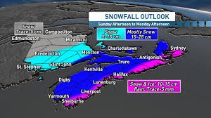
Atlantic Canada & Beyond
The system will conclude its journey across Atlantic Canada on Friday, bringing heavy snow and rainfall. The exact type and location of precipitation will depend on the storm’s final trajectory. A significant cooldown is expected to follow into Saturday.
Canada’s #1 most trusted weather brand and news source*
*2026 BrandSpark® Canadian Trust Study & 2026 Pollara Trust in Media Study