Toronto Weather: Brace for a Multi-Day Winter Storm
A complex and significant storm system is poised to bring a barrage of hazardous weather conditions to Ontario, with Toronto and surrounding areas facing a particularly challenging forecast. From prolonged freezing rain and ice pellets to localized and riverine flooding, residents are urged to prepare for a potentially disruptive week.
What’s Happening with the Toronto Weather?
Southern Ontario began the week with unseasonably mild temperatures, but that’s about to change dramatically. A powerful storm system, drawing moisture from the southern United States, is set to unleash a 24-plus-hour weather event across the province, starting late Tuesday and continuing into Wednesday.
A Breakdown of the Forecast:
- Tuesday: Foggy conditions will give way to increasing clouds and possible showers in southern Ontario. Mild temperatures will persist throughout the morning.
- Tuesday Evening: A mix of snow, freezing rain, and rain will begin to spread across central and southern Ontario. Southwestern regions may experience overnight thunderstorms.
- Wednesday: Heavy snow is expected east of Lake Superior. Prolonged freezing rain and ice pellets are anticipated east of Georgian Bay and towards the Ottawa Valley. Southern Ontario will see heavy rain and thunderstorms in the morning.
- Wednesday Afternoon: A brief period of warmth will be quickly replaced by colder air moving south, transitioning rain into a wintry mix or snow by evening.
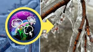
Freezing Rain: A Major Concern
Prolonged freezing rain poses a significant threat, potentially leading to multi-day power outages due to ice accumulation on power lines. Untreated surfaces will become extremely slick, and the weight of the ice could cause tree branches to break. Areas east of Georgian Bay and towards the Ottawa Valley are particularly vulnerable. The amount of ice accumulation will depend on factors like wind, precipitation rate, and surface temperatures.
Flooding Risks in Southern Ontario
Southern Ontario is also facing risks of localized and riverine flooding. Flood watches are already in effect, with flood warnings issued for communities along the Grand River, including Brantford, New Hamburg, and Haldimand County. Low-lying and vulnerable areas are at the highest risk of experiencing flooding and ice jams.
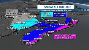
Snowfall Totals & Precipitation Amounts
- Snowfall: 5-15+ cm expected from east of Lake Superior to North Bay.
- Rainfall: 20-40+ mm possible in Southern Ontario.
- Freezing Rain: 5-20+ mm anticipated, primarily for Ottawa and eastern Ontario.
Stay Informed & Be Prepared
The storm track remains dynamic, meaning the areas most affected by snow and ice could shift. It’s crucial to stay informed with the latest alerts and updates from reliable sources. Here are some helpful resources:
Potential impacts throughout the week include power outages, treacherous road conditions, flooding, ice jams, and fallen tree branches. Take necessary precautions to ensure your safety and the safety of those around you.
Stay with The Weather Network for the latest updates on your local Toronto weather.
*2026 BrandSpark® Canadian Trust Study & 2026 Pollara Trust in Media Study – Canada’s #1 most trusted weather brand and news source.